Lower House, a three storey, red brick farmhouse, stands on the northern edge of Waters Upton village, on the West side of the road leading to Harebutt Bank and beyond. A report ⇗ produced for Telford and Wrekin Council in 2009 described the building as “an important introduction to Waters Upton” to those approaching the village via that road. It has stood there, silently greeting residents and visitors alike, since at least the 1700s – with the possibility that it, or an earlier building with the same name, performed that role even further back in time.
A List entry and a Chancery decree roll…
Because of its special architectural or historic interest, Lower House was listed on 8 Apr 1983. It is categorised as Grade II, with its list entry ⇗ (on the Historic England website) providing basic details of the building, and of the features which make it of special interest.
The List entry suggests that Lower House is an eighteenth century house which was remodelled in the early nineteenth century. I say ‘suggests’ because List entries are not always accurate ⇗ when it comes to the ages of the buildings they describe. And, as I noted above, there might be evidence of the Lower House – or at least a Lower House – existing at Waters Upton in the seventeenth century.
That evidence is in a Chancery decree roll held by The National Archives at Kew. I would have been blissfully unaware of this document, were it not for the Anglo-American Legal Tradition ⇗ website, a treasure trove of photos depicting TNA’s Medieval and Early Modern documents. Abstracts of the contents of many of those photos have also been created, and are searchable – which is how I discovered, via a site search for ‘Waters Upton’, the earliest mention I have found so far of Lower House.
C78 1723 ⇗ is the name of the page containing the aforementioned mention. C78 ⇗ is TNA’s reference for their collection of Chancery decree rolls, and 1723 is the year of the roll in question. An entry on that roll ⇗ dated 4 May in 1723 recorded details of a dispute over property including “all that other Messuage or Tenemt. called the Lower House in Waters Upton”.
The Chancery decree roll contains details of a number of legal documents relating to Lower House, including indentures dated the 25th and 26th June 1697. Those indentures related to “the Lower House or Hughes House“ – the latter name providing a possible clue as to the identity of the original owner of the property.
Was this the same building as the remodelled house of the same name that stands in Waters Upton today? Or was it an earlier abode, on the same spot or even elsewhere in the village, which has not survived? Given the issues with estimated building dates English Heritage listings, I suspect the former.
Brick dentil eaves and voussoired lintels…
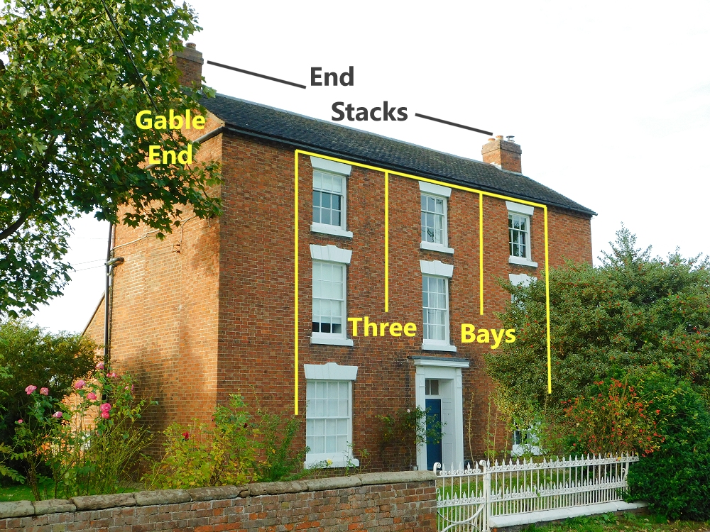
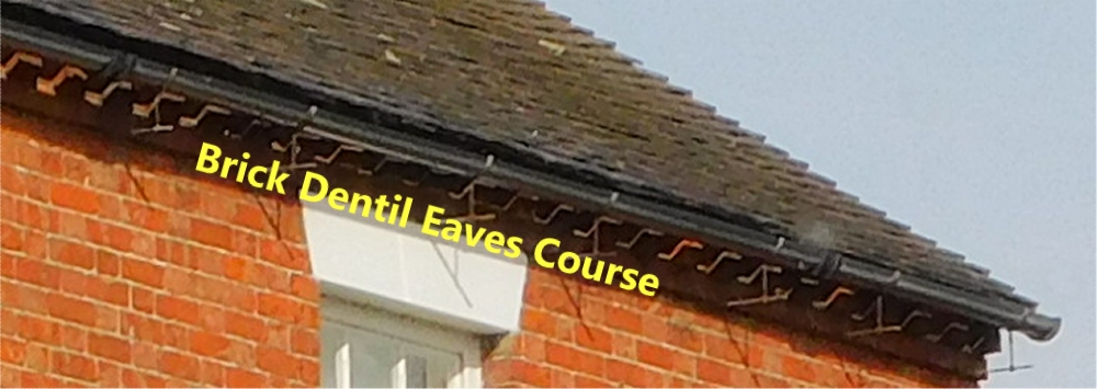
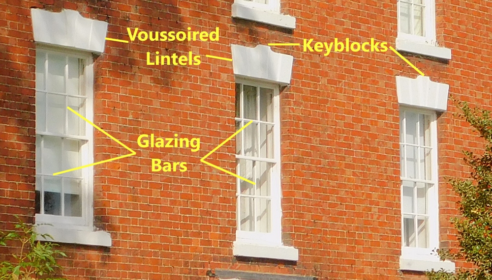
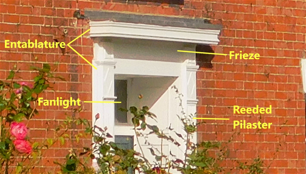
The List entry’s description of this dwelling’s architectural features is something we can be more certain about. Lower House is a three bay, three storey, red brick structure, with a tiled roof which has gabled ends and brick end stacks. Beneath the eaves of the roof is a brick dentil eaves course, with bricks sticking out in tooth-like fashion. (Hopefully the labelled pictures I have provided will help with interpreting some of these architectural terms; you may also find this glossary ⇗ useful.)
The sash windows have glazing bars to create the appearance of multiple panes of glass. Above the windows are voussoired lintels with keyblocks.
The central front doorcase has a reeded pilaster on either side, topped by an entablature with a panelled frieze. There are also panelled reveals and, above the panelled door, a rectangular fanlight. Apologies for not having a great photo of the door – when photographing the house I had no idea I would one day use the images in the way that I am now doing!
Structural elements of the late nineteenth century front garden are included in the List entry for Lower House. There is a dwarf brick wall with stone coping, and a fence of wrought iron railings with spear heads, at each end of which is a matching gate.
Earth Closet, Coal House, Tool House, Pig Pens…
Lower House as a messuage ⇗ (to use one of the terms used in the 1723 decree roll mentioned above) has always consisted of more than just the house itself. There are also the outbuildings and land that goes with it.
The indentures of June 1697 mentioned above refer to the following (I have added punctuation for ease of reading): “buildings, Barnes, Stables and other out buildings, Yards, Gardens, Orchards, Backsides, Lands, Meadows, Leasows, Pastures, Feedings, Woods, Woodgrounds, Fishings, Comons, Comon of Pasture, Turbary, Ways, Waters, Easements”.
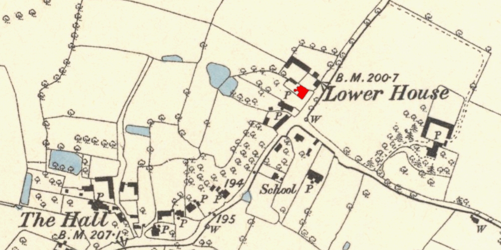
Large-scale Ordnance Survey maps, produced from the latter part of the 1800s onward (the one below was published in 1901) also show several outbuildings. What were they though? Thanks to the Valuation Office Survey, we know what almost all of them were (apart from one or two written illegibly) as of 1910-11. The relevant field book entry recorded the following structures:
- Earth Closet (Brick & Tile)
- Coal House (Wood & Iron)
- Tool House
- 3 Pig Pens
- Cow Tying for [6?] + 4
- 2 Bay Cart Shed & Granary over
- Barn
- Cow Tying for 5
- Root House
- Cow Tying for 5 & Loft over
- Stable for 2
- Trap House
- Loose Box & [Hack Stable?] for 1
- 2 Bay Cart Shed (Brick & Tile; Fair)
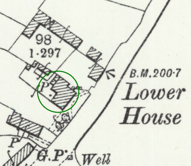
I hope to write in more detail about earth closets, cow tyings, root houses and other buildings enumerated by the Valuation Office Survey, in a separate post at a later date. For now, I will simply say that a recent estate agent’s brochure ⇗ lists the Lower House’s outbuildings as a converted barn (laid out as a home office with WC and kitchen), three garages, and a workshop. Also, the earth closet has long since been replaced by indoor WCs!
Dining & Drawing Rooms, Kitchen, Back Kitchen…
The Valuation Office Survey, which noted that the main house was of brick and tile, and in fair condition, also detailed the rooms inside it:
- Dining & Drawing Rooms
- Kitchen
- Back Kitchen
- Pantry
- 4 Bedrooms
- 2 Attic Rooms
- 1 Cellar
There is still a dining room and a drawing room, according to the aforementioned estate agent’s brochure. That brochure also shows a number of changes to the functions of some of the rooms. The ground floor featured a kitchen/breakfast room, a family room / playroom, a utility room, a boot room and an integral double garage. Upstairs meanwhile, it appears that one of the bedrooms on the first floor had become a family bath/shower room, while the attic rooms, the second floor of the house, had been converted into two bedrooms and a bathroom, with a study area on the landing.
So, who lived in a house like this (to paraphrase the catchphrase used in TV show Through The Keyhole)? That is a question I will return to in future posts.
To be continued.

