Waters Upton Landmarks – Part 2

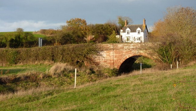
So far (in part 1 of this article) I have looked at rivers, bridges and inns as landmarks which would have been familiar and significant to people living in, visiting, or passing through Waters Upton. There were of course other buildings besides the pubs which could be considered landmarks, contributing to the unique character and identity of the village, including the church of St Michael’s and the Hall, set in its centre. I have written about the construction of modern-day St Michael’s in John Thomas Halke and the Church of Waters Upton; the church will feature again in future stories here, along with other buildings in Waters Upton. The landmark I am going to focus on now however, is one which lies several miles away from the parish.

View to a Hill

Head south out of Waters Upton on the A422 and almost immediately you will see a hill in the far distance. (Note: If you’re driving when you do this, keep a close eye on the road as well!) It doesn’t look like much from this distance, and to be fair, it’s not even in the top twenty of the highest Shropshire hills ⇗. Size isn’t everything however, and this landmark’s stature belies its significance within and even beyond the county. Say hello to the Wrekin.

The Wrekin has been described as “our best known hill and an iconic landmark for miles around” (see link above). On learning that the hill is only 407 meters (1,335 feet) above sea level, you might wonder why it is regarded with such affection. Roly Smith, writing in The Guardian in 2000, explains: “the Wrekin, which always proudly and significantly carries the definite article, is undoubtedly a hill with a presence. It rises so sharply and unexpectedly from the pastoral Severn Plain that it forces you to notice it.” He then added, “There are few mountains in Britain, let alone hills, that have exerted the same powerful influence or sense of place on its surrounding communities.”

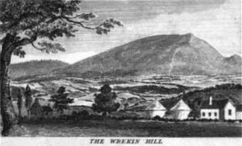
The Wrekin stands out. It is not a mountain, but a drop of over 150 metres on all sides ⇗ gives the Wrekin a certain prominence, especially in a landscape which is otherwise relatively flat – and also qualifies it as a ‘Marilyn’ ⇗. The Wrekin’s nearest Marilyn neighbours, Caer Caradoc and Brown Clee, are respectively about 20 and 30 kilometres away in Shropshire’s much hillier south.

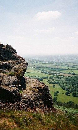
This prominence means that the Wrekin can be seen for many miles around, particularly from the north and east. As people travel into Shropshire from that latter compass point, on the M54 for example, the Wrekin stands a welcoming beacon. It calls for people to climb to its summit, and those who do are rewarded with outstanding views ⇗.

Dead Poets Society

The Rev Richard Corfield, Rector of Waters Upton from 1822 to 1865 (he was also Rector of Pitchford, where he spent much of his time), was one of many Shropshire souls familiar with the sights to be seen from the top of the Wrekin. He was also one of several authors who have set out their appreciation of the Wrekin in verse, albeit with a little poetic licence. The poem (dated 14 February 1833) can be read in full in Shropshire Notes and Queries; the following is an abridged version:

From Wrekin’s summit cast the eye around,
To view the objects which th’ Horizon bound;
O’er Salop’s plains with beauteous verdure drest,
The Cambrian Mountains stretch along the West.
The darksome Berwyn scowls with aspect drear,
Till Dinas Bran, and Moel Pam’ appear.
Turn to the North, and Hawkstone hills you see,
With Cheshire prospects reaching to the Dee.
When to the East, you bend th’ admiring gaze,
The barren Peak your startl’d thoughts amaze!
More Eastward still, you ken in distant view
Edge-Hill, where Charles his faithful follow’rs drew.
But dwell not here on scenes of discord past,
Look tow’rds the South, the prospect brightens fast;
The far fam’d Malvern breaks upon the eye,
And balmy breezes waft from Southern sky.
This fairy circle let us onward trace,
O’er Brecons beacons, Radnor’s forest chase;
And whilst on Caerdoc’s sister hills we stop,
In distant outline, lo! Plinlimmon’s top.
May then this mountain, fair Salopia’s pride,
Attract our footsteps to its summits side;
The summit gain’d, the weary toil’s repaid,
By prospects varied, mountain, wood, and glade;
And as the outline may be further known,
So past its limits may our love be shewn—
Love to our County—and to all held dear
By ties of kindred, friendship’s off’ring bear—
Love to our Country—and, to all friends round
The Wrekin’s circle, may our love resound—
Such wishes these all Shropshire hearts inspire,
In social converse round the Winter’s fire.

School of Rock

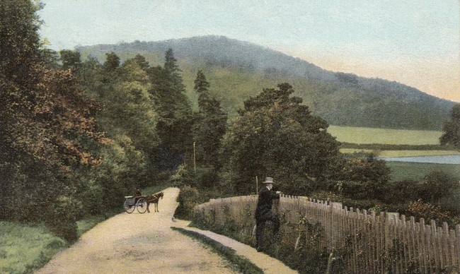
Waters Uptonians were as familiar with the Wrekin as any Salopians. We have already seen the hill can be seen from the road just south of the village, and in John Morgan, surgeon and apothecary of Waters Upton – Part 1 I included a notice advertising the availability of a “genteel residence” within the village which had “a commanding view of the Wrekin and surrounding country.” Such was the lure of this landmark that many made the journey to become more personally acquainted with it, including the children of the parish, for whom excursions to the Wrekin were arranged as an annual treat in the latter part of the 1800s.

The earliest reference to such visits that I have found so far actually relates to the children of the ‘Union School’ just beyond the Waters Upton parish boundary; a report published in the Shrewsbury Chronicle on 7 September 1860 noted: “At the last guardians meeting it was unanimously resolved on the motion of Mr. Minor, vice chairman, to give the children of the Industrial School, at Waters Upton, holiday to visit the Wrekin.” Almost thirty years on from that, a delightfully detailed description of a trip laid on for the village’s own children appeared in the Wellington Journal of 17 August 1889:

School Treat.—The children attending Waters Upton Parish School, accompanied by many of their parents and friends from the village, had their annual treat at the Wrekin on Friday, the 9th inst. Waggons and horses were kindly lent for the purpose by Messrs. Groucock, Cornes, Percival, Owen, Shakeshaft, and W. Rider. The waggons were tastefully decorated with wreaths of evergreens and flowers, given by friends the village, Miss L. Groucock and Miss Amos.
A start was made at 10 o’clock from the Rectory in fine weather, and the children seemed to enjoy the drive immensely from the merry noise they made on the journey and through the town of Wellington until the foot of the Wrekin was reached, when the party of about 120 had to unload and commence the walk up the hill. A rest was taken at the Upper Cottage for lunch, and then the whole party proceeded to the top of the hill, which was unfortunately clouded over with a thick mist. Afterwards the weather changed, and when the party had assembled at the Cottage for tea, which was supplied by Mr. S. Tudor, Post Office, Waters Upton, in the hospitable tents adjoining the Cottage, a severe thunderstorm came on, and the rain fell heavily, making the party thankful that they were under shelter.
At length, after enjoying an excellent tea and other good things, the presents of friends accompanying the excursion, a start was made for home about six o’clock. The return journey was made in most unfavourable weather, but, although nearly all the party got a thorough wetting, no ill effects have happened, and all are looking forward to an excursion another year under more favourable circumstances.
The children in the waggons were accompanied the Rector (the Rev. J. B. Davies), Mrs. Davies and family, Miss S. Groucock, Miss Amos, Misses Minor (Meeson), Mrs. J. Shakeshaft and family, Mr. and Mrs. James Tudor, Mr. and Mrs. A. Ridgway, and many others, and were joined on the hill by Mr. and Mrs. Percival, Mrs. Cornes and party, Mr. and Mrs. Owen and friends.

You will be pleased to know that better conditions blessed at least one subsequent school outing to the Wrekin. In July 1896, when 78 children and 40 accompanying friends headed for the hill in waggons “lent by Mr. H. F. Percival, Mr. S. Dickin, and Mr. W. Jerman”, they were “favoured with fine weather” and S (Samuel) Tudor once again provided tea. Several of those named in these reports will be familiar if you have read Late Victorian Christmases in Waters Upton; the others I will have to introduce you to in future articles.

This is the end

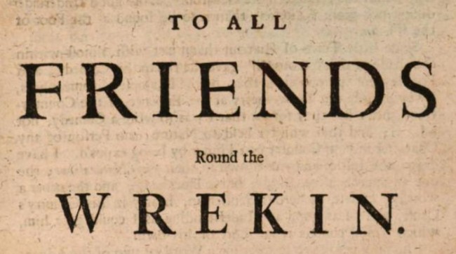
In my conclusion to part 1 of this article, I mentioned “the usual loyal and patriotic toasts” which were honoured in Waters Upton’s Swan Inn, in 1896. These would almost certainly have included one which the Rev Richard Corfield slipped in to his poem of 1833, namely “To all friends round the Wrekin”. (This should not to be confused with the saying “all around the Wrekin”, which has a similar meaning to “all round the houses” – or in other words, taking a longer route than necessary!)

The oldest appearance I have found in print of “all friends round the Wrekin” dates back to around 1706, when playwright George Farquhar used it to open the published version of his Shropshire-based comedy The Recruiting Officer (the image above is from Google’s electronic version of this long out of copyright work). Clearly it was well-established even then. I have found many later references to this toast in Shropshire newspapers – it appears that the tradition was to make it the final toast after all the others had been offered and drunk to, by way of recognising the special bond between those connected by their county’s most revered landmark. Although I have not yet found any specific references to its use in Waters Upton, I have no doubt that it was spoken there, often, and with feeling.


Picture credits. View of the Wrekin from Waters Upton: Embedded from Google Maps. The Wrekin hill: From the electronic version of The History and Antiquities of Shrewsbury, volume II (published about 1837 and therefore out of copyright) at Google Books ⇗. View from the Wrekin: Photo by Wikimedia Commons ⇗ contributor Northerner, modified and used under a Creative Commons licence ⇗. View of the Wrekin: From a postcard postmarked 1906 (in my own collection), out of copyright. To all friends round the Wrekin: From the electronic version of The Recruiting Officer (published about 1706 and therefore out of copyright) at Google Books (link in text above).

Waters Upton Landmarks – Part 1

The first of this year’s monthly blogging prompts from the Society for One-Place Studies ⇗ is ‘Landmarks’ (social media hashtag #OnePlaceLandmarks). Just in the nick of time, here is my contribution. I hope you will enjoy learning about Waters Upton’s landmarks – and playing ‘spot the film title’ too!

A promotional graphic created for the #OnePlaceLandmarks blogging prompt. The text read: Blogging and Social Prompts 2021. January | Landmarks | #OnePlaceLandmarks. A prompt for you to look at a physical element of your OPS, a landmark, which could be a building (for example a mill, a prominent institution, a ‘stately home’, or a church – in the latter case be aware of possible overlap with the Worship prompt in May), some other feature created by people (such as a canal, a bridge, an ancient earthwork) or a natural feature (which could be a hill, a river, a cliff or a wood). What is its history and significance? Which people or events are connected to it, and how? You can of course choose more than one landmark, especially if you are joining in by posting to social media.

A Sense of Place

What were (or are) the landmarks of Waters Upton? Before I identify and write about some of them, maybe I should first ask a more fundamental question – what is a landmark? According to Wikipedia ⇗ (which isn’t the last word on the subject but is, with some modifications, absolutely fine for my purposes):

In old English the word landmearc […] was used to describe an “object set up to mark the boundaries of a kingdom, estate, etc”. Starting from approx. 1560, this understanding of landmark was replaced by a more general one. A landmark became a “conspicuous object in a landscape”. A landmark literally meant a geographic feature used by explorers and others to find their way back or through an area. […]
In modern usage, a landmark includes anything that is easily recognisable, such as a monument, building, or other structure. In American English it is the main term used to designate places that might be of interest to tourists due to notable physical features or historical significance. Landmarks in the British English sense are often used for casual navigation, such as giving directions. This is done in American English as well.
In urban studies as well as in geography, a landmark is furthermore defined as an external point of reference that helps orienting in a familiar or unfamiliar environment. Landmarks are often used in verbal route instructions and as such an object of study by linguists as well as in other fields of study.

So, landmarks are man-made or natural features (categories which in reality can merge), which stand out visually through their size, their distinctive appearance, or a combination of these characteristics. They are also features which, by enabling people to identify where they are and where they are going, make their mark on us.

A River Runs Through It

Actually, two rivers run through the modern day parish of Waters Upton. And before its expansion to Bolas Magna and part of Ercall Magna, those rivers ran around parts of the parish boundary. The Tern formed the western perimeter of Waters Upton, and the northern edge of the parish followed the Meese, one of the Tern’s tributaries. While they are not objects which were ‘set up’ to mark land boundaries, these watercourses delineated an extensive part of the historic parish border.

Travellers heading south from Cold Hatton Heath on the road from Market Drayton to Wellington would have known, on seeing the Tern to their left, that they were nearing Waters Upton. A little further on, crossing another landmark – the bridge carrying the road over the Tern – took them into the parish proper. A welcome sight no doubt to those for whom Waters Upton was home.

Extract from an old Ordnance Survey map showing Waters Upton and some nearby settlements (Cold Hatton Heath, Great Bolas, Meeson, Meeson Heath, Harebutt Bank, The Terrill, and Shray Hill). The River Tern, which flows from near the middle of the top of the map down to the bottom left corner, is shaded blue, as is its tributary, the Meese, which runs East to West across the map from near the top right corner. Those parts of the Waters Upton parish boundary nor marked by a river, i.e. to the East and South, are highlighted with red dashes.
Map showing Waters Upton, the River Tern to the west, the River Meese joining the Tern from the east (both rivers in blue), and those parts of the historic Waters Upton parish boundary not following rivers, to the east and south (red dashed line).

Bridge Over the River . . . Tern

Not everyone crossed the bridge over the river Tern without incident, as this report from the Lancashire Evening Post of 20 September 1906 shows:

SKID ON A BRIDGE.
GRAND DUKE’S STEWARD PITCHED INTO A RIVER.

An alarming motor car accident occurred at Waters Upton, a village situated between Wellington and Market Drayton, Salop, yesterday afternoon. A party from Keele Hall, Staffordshire, the residence of the Grand Duke Michael, consisting of Mr. Reid (Morecambe), Mr. Cooke (Keele), the Grand Duke’s Michael’s steward, the chauffeur, and a Mr. Shakeshaft were motoring from Keele on a visit to a relative of Mr. Shakeshaft’s at Waters Upton. All went well until a quarter of a mile from the village. The car was proceeding round a sharp corner down a slope at the bottom of which a narrow bridge crosses the river Tern. The driver saw that the car was going for the parapet of the bridge, and the vehicle skidded. The car turned almost round on the bridge, knocking down the parapet, and all the occupants were thrown, the steward landing in the river below, the water being four or five feet deep at this spot. The villagers soon came to the assistance of the party, and it was found that the steward was not seriously injured.
Dr. Hawthorn, of Wellington, was summoned, and the injured people carried into the village inn. Mr. Shakeshaft has a broken leg and slight concussion of the brain, the head and neck being cut; Mr. Cooke has nasty cuts on the hands and face; and the driver is also badly injured, his forehead being severely cut. Two of the injured were detained.
The road is narrow where the accident happened, and after the bend there is a steep decline to the bridge, which is hardly wide enough for two vehicles to pass each other.

Other newspapers gave slightly different accounts, which help to fill in some of the gaps in the one above while also adding one or two elements of confusion. To give one example, the Wellington Journal (22 September 1906) stated that Mr Shakeshaft “sustained a broken ankle” rather than a broken leg, but on the plus side it also identified him as “Mr. John Shakeshaft of Morecambe (cousin of Mr. John Shakeshaft, Waters Upton)”.

Another paper, the Burnley Gazette (also 22 September 1906), noted that the injured Mr Shakeshaft kept the Dog and Partridge Hotel in Morcambe and had married “a daughter of Mr. Tattersall Wilkinson, of Roggerham” (near Burnley). Google led me to a page for this John Shakeshaft on the Halsted/Halstead One-Name Study Narratives ⇗ website, and switching from there to Ancestry and Findmypast eventually enabled me to work out how he was related to his namesake at Waters Upton.

The two John Shakeshafts were first cousins one generation removed. John of Waters Upton, who was about 59 years of age in 1906, was the John Shakeshaft who I referred to as an occupant of The Beeches in my recent story A Waters Upton postcard. The location of The Beeches meant that this John Shakeshaft was just a short walk away from his 46-year-old cousin of the same name while the latter was recuperating in the Swan Inn.

The Tern bridge had most likely been rebuilt and repaired on a number of occasions by 1906, but its age at the time of the accident eludes me. What I do know is that the bridge now in place is not an ancient structure. The Kington Times of 8 November 1930 reported on several schemes which had just been adopted by Salop County Council, including one for “erecting a new bridge and improving the approaches to it over the River Tern at Waters Upton”.

Photo of a view across part of a grassy field to Bolas bridge (a small structure of pale brown stone) and beyond. The River Meese, which flows beneath the bridge, is not visible in this picture, although the tops of its banks can be seen. Beyond the bridge, on higher ground, a small, two storey house with white- or lime-washed walls can be seen.
Bolas bridge.

Rather more ancient is the bridge crossing the Meese just beyond the historic boundary of Waters Upton. Known as Bolas Bridge, it was built in 1795 by one Richard Madeley – and (according to the record of its Grade II Listed ⇗ status) it has the inscription to prove it! Anyone travelling between the villages of Great Bolas and Meeson, or between either of those places and Waters Upton, crosses (or crossed) that bridge, making it (and the adjacent turn to Waters Upton on the Bolas – Meeson road) another landmark.

Ring of Bright Water?

The Tern and the Meese were more than just landscape features defining parts of Waters Upton’s boundary – they were a part of people’s lives and local folk interacted with them in a variety ways. Here, I am going to look at one of those riverine activities, one which I find utterly abhorrent, but which is part of the history of my Place: otter hunting.

I have found several newspaper reports from the 1880s and ‘90s relating to otter hunts taking place along the Tern, the Meece, or both, in the vicinity of Waters Upton. On Tuesday 10 May 1887 for example (according to the Wellington Journal of 14 May 1887), the Hon. Geoffrey Hill’s Otter Hounds met at the village. From there, the hounds moved downstream and picked up the scent “scarcely 100 yards from Waters Upton”. Two otters were bolted from a well-known holt; one was a cub who soon met its end in the jaws of a hound named ‘Sportsman’, “but the other afforded a capital hunt of some 45 minutes.”

This otter, a small female who was most likely the cub’s mother, spent most of the last 45 minutes of her life evading the hounds or fighting them off when they got too close. Towards the end, when she took refuge beneath the roots of a tree, she was pursued by a terrier (‘Frank’) and fought him off too. After she was caught and killed, “it was seen that poor Frank, who had suffered severely in his conflict with the otter, was in bad case in the river, his head covered with blood and himself exhausted and half drowned.” The rescue of the terrier from the river meant that “the call to lunch […] could be attended to without any regret.” After lunch the dogs were transported back to the starting point and then along the Meese as far as Bolas before the hunt was abandoned. There were no further kills.

I do not know whether any Waters Upton residents took part in these hunts or followed on foot. The Swan Inn did very well out of the hunts’ visits however. When Captain Foster and his hounds visited Crudgington in July 1894, the hunt went downstream in the morning, then headed back upstream as far as Peplow Hall. “Acting thus,” reported the Wellington Journal on 28 July 1894, “gave pedestrians an opportunity to warm up a little, and the carriage-folk a nice run round the road to Waters Upton Bridge, and storm the good cheer provided by genial Host Owen the Swan, the well-known old sporting house […]”. No otters were seen that day.

A photo of a European Otter. The animal is standing in some grass, which hides his or her legs, feet, and tail, and is facing towards the right. The fur is mostly brown, but is whitish on the cheeks , throat, and the underside of the neck down to the chest.

The Tern – and the Swan – played host to fishing enthusiasts too. When a club from Crewe visited in January 1896 for a nine-aside fishing match, its members and their guests ended the day with “a capital supper, provided Mr. and Mrs. Owen, of the Swan Inn”, after which (in the words of the Wellington Journal, 1 February 1896) “the usual loyal and patriotic toasts were honoured” and songs were sung.

Further reports of fishing in the Tern at Waters Upton can be found in digitised newspapers through the 20th century. Otter hunting, thank goodness, became illegal in 1978 after the otter population in England crashed; the species is now doing well in Shropshire ⇗ (including the area around Waters Upton) and elsewhere. As for the toasts honoured in the Swan and other pubs in Shropshire, one of them forms the subject of the second part of this story…


Picture credits. One-place landmarks blogging prompt graphic: By the author, for use by the Society for One-Place Studies and anyone taking part in the blogging challenge. Map: Extract from Ordnance Survey One Inch map Sheet 138 ⇗ published 1899; reproduced with the permission of the National Library of Scotland and used under the Creative Commons licence. Bolas bridge: Photo © Copyright Richard Law; taken from Geograph ⇗ and modified, used and made available for reuse under a Creative Commons Licence ⇗. Otter: Public domain image from Pixabay.