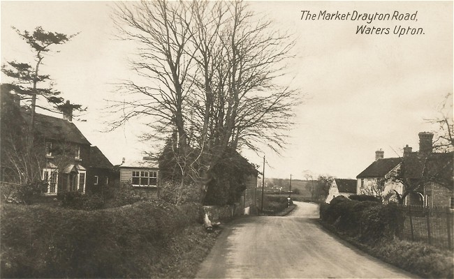
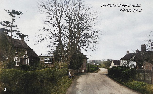
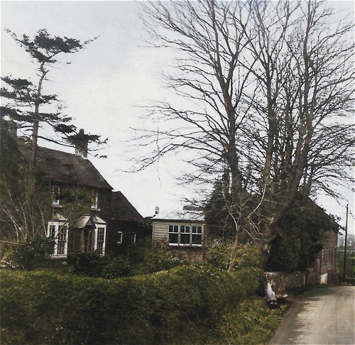
Although I acquired a postcard sent to Waters Upton a little back (see Lucy Alice Wylde and her secret admirer), it is only during the last week that I have finally managed to get my hands on a postcard showing a scene of the village. And here it is: Market Drayton Road, Waters Upton.
Where was ‘there’?
Now, of course, I have questions! From where exactly was the photo taken? What can we see in the picture – which houses are they on either side of the road, and in the distance? When was the photo taken? How does the view today compare with the one captured in the photo?
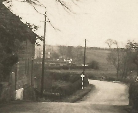
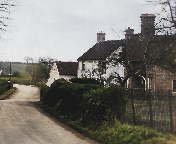
A virtual visit to Waters Upton via Google Street View ⇗ goes a long way towards answering the first and last of my questions. It isn’t possible to match up a ‘now’ Street View to the ‘then’ postcard image exactly, because the Street View camera grabbed its images from the other side of the road. This is the closest I can manage (also, note that this picture is from 2009 rather than ‘now’).
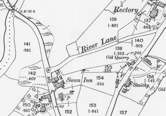
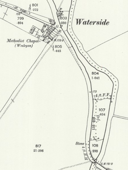
Thanks to the National Library of Scotland’s marvellous map collection, I have also found an Ordnance Survey map showing the layout of the buildings and other features depicted in my postcard. This map, at a scale of 25 inches to the mile, is incredibly detailed. It was published in 1901, based on revisions undertaken the previous year. Whoever took the postcard photo was probably standing somewhere to the south of the spot height of 182 feet marked on the map.
And when was ‘then’?
We’ve seen the scene from around ‘now’, but when was ‘then’? Although a precise answer isn’t possible at the moment, the picture on my postcard is unlikely to correspond to the date of the Ordnance Survey map above. The card was never posted so it doesn’t have a postmark, but there are other clues and they point to a later date than the turn of the century.
The back of the card doesn’t give much away. What little text there is does not name of the company which printed or sold it. All it says is “POST CARD”, with the words “BRITISH MANUFACTURE” below that, “Communication” and “Address” a little lower down on the left and right hand sides, and running up the middle of the card “A Real Bromide Photograph”. I have however seen images online of postcards matching mine in these details, posted around 1930.
I have found more evidence on the Shropshire Star website, in an article from 26 February 2010. Under the heading Pictures from the past ⇗ it shows a black and white image another postcard featuring Waters Upton. This too was taken from the Market Drayton Road, but further to the south. Its title, printed in an identical typeface to that used on my postcard, is Post Office & Garage, Waters Upton. The trees in the photo, like those on my postcard, are bare. I’m willing to bet that the scene was captured by the same photographer, and on the same date, as the one I have. According to the Shropshire Star, the postcard was franked on 21 August 1936.
Life on the edge
So the scene captured on my postcard probably dates from the early 1930s or thereabouts, and is a view taken from the edge of the village and parish rather than from its centre. The photographer was looking north-north-west along the course of the road to the bend, beyond which, just out of sight, it crosses the River Tern and the parish boundary. The road then turned back the other way, following the river and eventually becoming Sytch Lane.
At the point where a road to Rowton branched off was a place known as Waterside. The Ercall Magna poorhouse – later a Wellington Poor Law Union workhouse, and later still the Union’s school – was located there (see Refuges of Last Resort: Shropshire Workhouses and the People who Built and Ran them ⇗, pages 73 – 76). After a new workhouse (with its own school) was completed in Wellington in 1876, the premises at Waterside were sold and became known as the Union Buildings. Can we see one of them, behind the first of the two telegraph poles visible in this picture? And can we see sheets hanging out to dry, to the right of the house? Unfortunately the original image can be only be enlarged so far before it begins to get fuzzy.
Although the area captured on camera here was not physically in the middle of Waters Upton, it was very much a part of the village’s commercial heart. The Market Drayton road, running between that town and Wellington, was a well-used transport route in this part of Shropshire. For most of those who used it, the part of Waters Upton that lay beside this road was probably the only side of the settlement they saw.
Where everybody knew your name
Taking advantage of the passing trade while also serving the locals, both of Waters Upton’s pubs were situated here. The oldest of the two, the Swan Inn, can be seen on the right hand side of the view in my postcard – the two white-coloured buildings. The 1934 Kelly’s Directory covering Shropshire shows that Joseph Madeley was then the innkeeper. He was still there five years later when the National Identity Register (better known today as the 1939 Register) was taken, with his wife Nellie Ann, née Meller. The 1921 census shows that Swan had seven rooms; the census of 1911 however records nine and the Valuation Office Survey field book entry from 1910/11 lists the following: Tap Room, Smoke Room, Snug, Kitchen, 5 Bedrooms. I will have much more to say about the Swan, its other occupants and some of its customers in future blog posts!
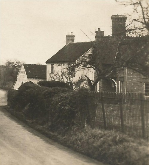
Next door to the Swan and closer to our viewpoint is a building which, Google Street View reveals, is named Sutherland Cottage. It was recorded under this name when the 1939 Register was compiled, when it was occupied by Mary Ann Woolley (née Shuker). Mary was the widow of railway ganger / platelayer Samuel Woolley, who died in 1936. His National Probate Calendar entry gave his address as 20 Waters Upton – which corresponds with Sutherland Cottage. It seems likely to me therefore that Samuel was living at Sutherland Cottage, with Mary Ann, at the time when the photo on my postcard was taken. The couple, and three of their children, were also enumerated at 20 Waters Upton on the 1921 census.
Was Sutherland Cottage also the home of the Woolley family when the censuses of 1891, 1901 and 1911 were taken? I think it was. Although the name of the building was not recorded on those censuses (or any prior to them), on all three occasions it was the next household to be enumerated after the Swan – just as it was in 1939. The 1911 census recorded that it contained four rooms in addition to the kitchen. Furthermore, the Valuation Office Survey field book entry from 1910/11, confirming the owner as the Duke of Sutherland and the occupier as Samuel Woolley, records the address as 20 Waters Upton.
The name Sutherland Cottage indicates that the property was built by the Duke of Sutherland ⇗, who was a big landowner in Shropshire – though not in the parish of Waters Upton (the tithe maps and apportionments show that his holdings there were very small). Duke of Sutherland cottages, though not identical to each other, seem to have had a particular character; here is a great example from Burlington near Crackleybank in Shropshire.

Left ‘til last
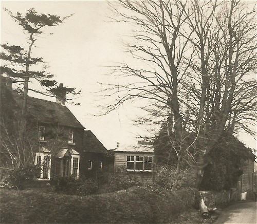
Across the road from Sutherland Cottage on the left hand side of the photograph, a large brick building can be seen. It has the appearance of something built and used for agricultural purposes rather than as a dwelling. Also on the left-hand side but closer to the camera is a house with a single storey extension and a small wooden building in its grounds. The house is The Beeches (a.k.a. Beech Cottage).
The 1934 Kelly’s Directory covering Shropshire and the 1939 Register show that The Beeches was then occupied by John Brookes, a farmer or smallholder, and his wife Emily (née Fletcher). It was listed immediately after the Swan and Sutherland Cottage on the 1939 Register – and in the same way (with the same name!) on the enumerator’s summary schedule for the 1911 census. The house was however recorded between the two aforementioned properties on the 1921 census. This is the earliest census showing John Brookes, and Emily (then housekeeper Emily Fletcher), as residents of The Beeches.
In 1911 the house was occupied by John Shakeshaft, a corn merchant, along with his wife Elizabeth (née Taylor) and their sons Joseph and Robert. (Curiously, the Valuation Office Survey field book entry from 1910/11 lists the occupier as Robert Shakeshaft.) As with the Woolley family, it appears that the Shakeshafts were living in the same house in 1901 and 1891 as the one they occupied in 1911. John was described as a general merchant in 1901 and as a corn and coal merchant and farmer in 1891. On neither of these censuses was the house named, but as would happen in 1911 and 1939 it was enumerated immediately after the Swan and Sutherland Cottage. I suspect it was also where the Shakeshafts lived in 1881 (their first appearance on a census at Waters Upton), even though their household did not appear on the census schedule in the same sequence as in later years. John was then a corn merchant and farmer of 12 acres. He died in 1919.
And now for something completely different?
As we have seen from Google Street View ⇗, things have changed in the eighty to ninety years since the photograph on my postcard was taken – though thankfully not so much as to make the view unrecognisable. Among the most noticeable changes are:
- The loss of the Scots pine, the deciduous trees and the wooden building, adjacent to the house which may have been The Beeches (and the appearance of non-native conifers in the vicinity)
- The flattening of that dip in the road, and the addition of road markings
- The loss of the smaller of the two white-coloured building that made up the Swan Inn
- Since the Street View camera’s visit, the gutting of the Swan by fire 2015 (the front face of the building remains but the roof and much else has gone; the Shropshire Star reports ⇗ that plans have been submitted to build houses and a community centre on the site)
- The replacement of the roadside hedges at the front of The Beeches (?) and Sutherland Cottage with walls (or the removal of vegetation which had obscured walls which were there all along?)
- The loss of the view beyond the bend in the road due to growth in roadside hedges and trees
A further change, out of sight, is that Sytch Lane and the stretch of road leading up to it has been bypassed. The ‘Market Drayton Road’ is now referred to (at least by the Shropshire Star in the report linked to above) as Long Lane, and it is classified as the A442, which goes to Whitchurch. At Hodnet however, it briefly merges with the A53 and that road takes travellers to Market Drayton.
Finally, on the subject of changes, how about a conversion of the sepia tones of the original Bromide photograph into colour? Here is the result of using the MyHeritage In Color™ ⇗ tool, and tweaking the result in Paint Shop Pro.

Interesting to see mention of Joe Madeley, landlord of The Swan. His wife was called Nelly. He was a cousin of my great grandmother, Alice Williams (nee Whitfield). I have photos of Joe & Nelly which I’m happy to share.
LikeLiked by 1 person
That’s interesting, I have an Alice Whitfield in my Waters Upton family tree/forest on Ancestry. Born about 1885 in Tyrely, Staffordshire, daughter of Richard Whitfield (who was born in Waters Upton about 1845 and died at Hodnet in 1909) and Mary Batho (1857-1932). Yes please, would love to see the photos of Joe and Nelly (née Meller). You could either DM them via my personal Twitter (AtcherleyOrgUK) or via my Society for One-Place Studies email (which can be found here: https://www.one-place-studies.org/europe/england/shropshire/waters-upton/). Thank you! 🙂
LikeLike
Hello, I am a descendant of the Woolley family from Sutherland Cottage next to the Swan (as was?). There is a story in the family that the landlord’s agent came to my great grandmother Mary’s house and asked if there was anything she needed, to which she replied “a new house”. Apparently the first load of bricks – for the Sutherland Cottage – arrived the next week. I think you may have a service record of Robert Earnest Woolley in WWI, his younger brother Stanley Thomas Woolley was warded the Military Medal in WW2. I just about remember Stan from my childhood – quite a character. Martin.
LikeLike