Towards a house history of… the Lion Inn (Part 1)

For my first contribution towards a Waters Upton house history I’m going to look at one of the few older properties in the parish which can, throughout its existence, be identified by name in most records relating to it. Today it is the Bharat Indian Restaurant ⇗, and for a while in the 1800s it was known as the New Inn, but for most of its near 200 year history this home and business premises was named the Lion Inn.

The Lion Inn, as seen in the early 1900s on a Wilding postcard in my collection. Image enhanced and cropped from original.

Before I attempt to give the Lion the House Through Time treatment, I should explain what I mean by ‘towards a house history’. Because of data protection and privacy requirements, and the related issue of more recent records being less accessible, my one-place study of Waters Upton officially ends around the beginning of the Second World War. The same will apply to the accounts of the houses of the parish which I am compiling and will share on this website. In the case of properties which still stand, I will of course include information about them as they are today, but there will be about eight decades of their most recent histories missing. That still leaves a decent period of time for us to look at!

In addition, this post (and others like it, to follow in due course) will provide only an introduction to the people connected with the house. The owners and/or occupants who I have managed to identify will be discussed briefly, with the aim of exploring their stories in more detail later. When those stories are added, I will update this post to include links to them.

Finally, I have yet to consult all of the available records. There are electoral registers and more besides held at Shropshire Archives in Shrewsbury, patiently waiting for me to take a look at them and extract the data they hold. Rather than wait until I have done so before embarking on this house history journey however, I have chosen to share what I have, knowing that I can update things later. I’ll now get on with doing exactly that.

Inn like a Lion…

A notice published on the front page of the Shrewsbury Chronicle of 21 June 1833 provides a beginning for the Lion’s story, nearly two centuries ago:

ELIGIBLE
FREEHOLD PROPERTY,
At Waters Upton and Wellington.
TO BE SOLD BY AUCTION,
By Mr. WYLEY,
At the Lion Inn, Waters Upton, in the County of Salop, on Wednesday, the 26th Day of June, 1833, at Four o’Clock in the Afternoon, subject such Conditions as shall be there and then produced, and in the following or such other Lots as shall be agreed upon at the Time of Sale:
LOT I.
ALL that newly-erected and well-accustomed PUBLIC HOUSE, or Licenced Beer House, called The Lion, situate at Waters Upton aforesaid now in the Occupation of Samuel Nickless, with the Stables, Cowhouses, Walled Garden, and Premises thereunto belonging.
And also all those Four small Pieces of good Meadow and Pasture LAND, lying together and adjoining the House, and containing three Acres or thereabouts, also occupied by Samuel Nickless.
The House consists of excellent Cellaring and spacious and commodious Kitchen, Parlour and Lodging Rooms. It is admirably adapted for Business of any kind, being situate adjoining the Road leading from Wellington to Whitchurch, and at the corner of the Road leading from that Road to Market Drayton, &c. and part of the Premises may at a trifling expense be converted into a Shop. […]

What a wonderfully informative notice! Not only do we find from this that the Lion was “newly-erected”, we also get an impression of the house itself, with its “excellent Cellaring” and those “spacious and commodious” rooms.

The 1911 census recorded that the building had seven rooms (including the kitchen but not including any scullery, landing, lobby, bathroom or closets); the 1921 census says nine. The reason for the apparent increase is not clear. The building might have been extended between the censuses, or a couple of rooms may have been divided. Or the head of the household – the same person in both years – may simply have interpreted the instructions differently on each occasion. Curiously, the room count for the nearby Swan Inn went from nine in 1911 to seven in 1921!

Pride of place

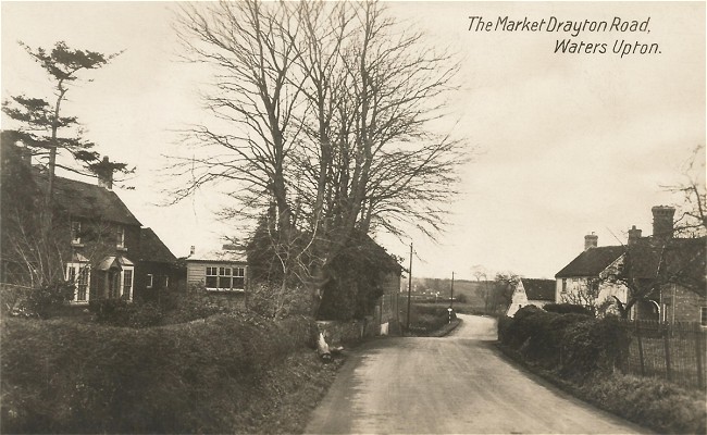
Amongst the other information in the 1833 auction notice is a description of the Lion’s location. The house stands on the East side of what is now the A442, the Wellington to Hodnet and Whitchurch road, on the South side of its junction with the main road through Waters Upton village (from which a far from direct route to Market Drayton can be followed). An ideal location to tempt thirsty travellers or workers (such as waggoners) passing by, while also being well situated for local customers.

The other buildings belonging to the Lion – “Stables, Cowhouses, […] and Premises” – and adjoining parcels of land occupied along with the house (and its walled garden) – “Four small Pieces of good Meadow and Pasture […] containing three Acres or thereabouts” – are also noted in the auction notice.

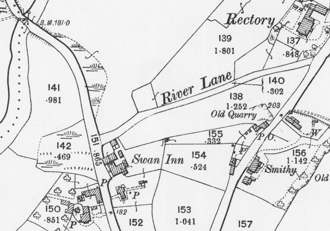
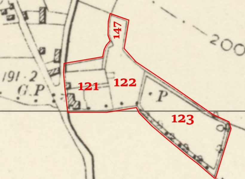
The tithe map and apportionment records created in 1837 provide details of at least some of these pieces of land. A “House [Buildings] Garden & Croft” (number 121 on the tithe map) corresponds with the Lion’s location. The owner of that property also possessed Middle Marsh (122, pasture, two roods and 20 perches in extent), Lower Marsh (123, meadow, one acres, two roods and 28 perches) and piece of land described as a Garden (147, no description of cultivation given, 25 perches in extent). Below, on an extract from a later (Ordnance Survey) map, I have drawn a line to indicate the boundary of those pieces of land and added the numbers from the tithe map.

Map adapted from an extract from NLS Maps ⇗. Reproduced with the permission of the National Library of Scotland under a Creative Commons licence ⇗.

The nature of the beast

Another snippet from the notice of the Lion’s sale in 1833: the property was described as a “PUBLIC HOUSE, or Licenced Beer House”. It seems likely that the Lion was one of the thousands of new public houses which appeared in the wake of the Beerhouse Act 1830 ⇗. Under this Act any rate payer could apply for a licence (costing two guinea annually) to brew and sell beer on their premises.

No clue as to the original owner of the Lion and its associated land is given in the notice of sale, but the above-mentioned tithe apportionment records of 1837 probably tell us who purchased the property – although there is some confusion over his exact identity. The apportionment agreement referred to a William Felton as “the Owner of a Messuage Garden and several Closes of Land containing by Estimation Three Acres and twenty two perches Statute Measure”. However the accompanying schedule names the landowner as Thomas Felton – perhaps the same Thomas Felton who appeared on the 1841 census at Waters Upton as a publican.

I have my doubts about Thomas being the owner, not least because the register of voters for 1842-43 includes William Felton, with abodes at Rowton and Waters Upton, as the owner of a “Freehold house and land” at Waters Upton – occupied by Thomas Felton. Subsequent registers, up to that of 1850-51, state that William Felton had his abode at Bratton in the parish of Wrockwardine, and referred to his house and land at Waters Upton as the Lion Inn.

William Felton does not appear as a Waters Upton voter in the electoral registers after 1850-51. This corresponds with the death ⇗ of a 77-year-old William Felton, registered in Wellington Registration District in the first quarter of 1851. I believe he was the William Felton enumerated on the 1841 census ⇗ at Rowton as a farmer, his age (likely rounded down) given as 65. It appears that his son John Felton then inherited the Lion – and went on to change its name.

Between the Lions

John Felton of Bratton appeared in the lists of voters as the owner of a freehold house and land at Waters Upton before his father’s death. He was likely the John Felton, son of William Sarah, baptised ⇗ 25 May 1806 at Kinnersley (nowadays Kynnersley). He wed Melona Meredith ⇗ at High Ercall on 2 October 1837, at which time (according to the allegation made when he applied for his marriage licence ⇗) he was a butcher. In 1851 he was recorded on the census ⇗ as a farmer of 184 acres, living with wife Melona and their children at Long Lane in the parish of Wrockwardine.

John’s property in Waters Upton was not identified by the name of the house or its occupier in the aforementioned lists. Similar entries in those lists continued up to and including that of 1858-59. Then, from 1859-60 until at least 1871, we see John Felton of “Long Lane, near Wellington, Salop” as the owner of a freehold house and land at Waters Upton named as the New Inn.

The establishment formerly known as the Lion appears as the New Inn on the censuses of 1861 and 1871. During the 1870s however the inn’s original name was restored – the earliest reference I have found so far is in a report in the Wellington Journal of 14 October 1876 (page 8). The Lion’s return may well have been a consequence of the death – on 19 July 1875 at Long Lane according his entry in that year’s probate calendar – of John Felton.

I have yet to trace the ownership of the Lion from 1875, although I do know (thanks to the Shrewsbury Chronicle of 1 March 1907, page 8) that on 28 February 1907 “the ‘Lion’ public house, at Waters Upton, with some 3 acres of land, was sold to Mr. W. T. Southam, Shrewsbury, for £850.” There are however other people connected with the history of this house for us to look at – particularly those who lived there and called it home. I will introduce them to you in Part 2.

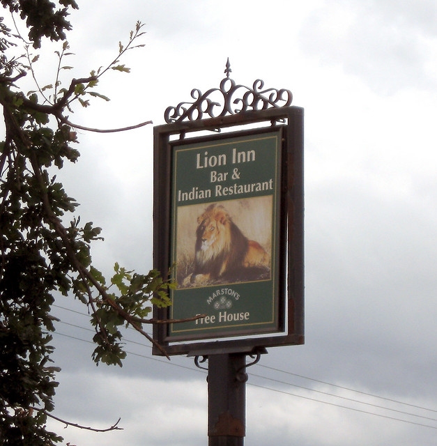
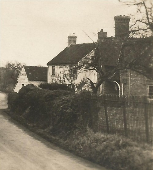
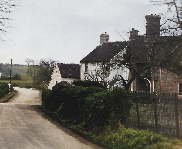
The Lion Inn, between its days as an inn and its current existence as the Bharat Indian Restaurant. Photo by Harry Pope, taken from Flickr and used under a Creative Commons licence.

By the numbers: How Waters Upton’s doors got their digits (Part 1)

House numbers are something we take for granted these days, but it hasn’t always been that way. They didn’t exist in England before the beginning of the 1700s, and they did not appear in Waters Upton until another two centuries had passed. Here are some edited highlights from the 200-year story of the spread of house numbering, from London to other urban areas, and from Shropshire’s towns to its rural parishes, including Waters Upton.

My interest in house numbering, particularly in the parish of Waters Upton, stems from my desire to research the histories of individual houses there as part of my wider one-place study. For me to be able to do this, I need to be able to distinguish one house from another in records relating to the place and its people. The absence of house numbers before the early 1900s makes this a tricky task.

There were a few houses with names of course (The Hall, the Swan, the Lion Inn), and a couple which can be identified from the occupation of the ‘head of the household’ (the rectory, the smithy). There are also a couple of hamlets in Waters Upton parish (the Terrill, the Harebutts) each consisting of just a few houses (and each with a variety of variant spellings in days gone by!). If house histories are not possible for those places then ‘hamlet histories’ – smaller one-place studies within a larger OPS – might be feasible.

What about street names, which were around long before house numbers (my favourite being Shall-I-go-naked Street ⇗ in Whitechapel St Mary)? In common with many other small settlements, the road along which most of the village’s houses are situated does not have a name. There is the Market Drayton or Hodnet road of course, on the west side of the village, but few of Waters Upton’s homes faced onto this (two of those that did were the inns, which can be identified from their names). And back in the days before Waters Upton expanded, the one road with a name – River Lane – was not a residential street.

The absence of a named street and of numbered houses would not have been a great problem in a small village like Waters Upton. Those seeking a particular house or its occupants would no doubt have been pointed in the right direction soon enough by one of the villagers. In larger settlements however, and particularly in cities like London, a plethora of properties made things more complicated. How did people find the building they were looking for?

“Before house numbers,” says The Postal Museum ⇗, “businesses used illustrated signs to show people where they were”. In times of less than universal literacy, such signs, using images rather than words, were an important part of the ‘visual culture ⇗’ of towns and cities. As Kathryn Kane states in her blog post On the Numbering of Houses they would have “served as landmarks by which a person could give directions to their residence.”

Those who could wield a quill had to write out such directions, rather than addresses as we know them today, when sending letters. I suspect the shortcomings of this way of doing things became more and more apparent as the population, and built-up areas, expanded.

The earliest reference to houses in England being numbered appears in the first volume of Edward Hatton’s A New View of London, published in 1708. Describing “Prescot street, a spacious and regular Built str. on the S. side of the Tenter Ground in Goodmans fields,” Hatton said that “Instead of Signs, the Houses here are distinguished by Numbers”.

It does not appear that this early experiment sparked immediate imitation elsewhere. The notion of numbers being used to identify properties did eventually catch on though, and in the latter part of the 18th century received ‘official’ approval. This came about as part of much broader efforts to tackle the state of the streets in and around the city of London.

Writing about these times in his Modern History of the City of London (1896), Philip Norman stated: “The condition of the paving in the roads and foot-paths of the City [had] long given rise to complaints”. He also observed that “The want of proper tablets to distinguish the names of streets and courts, and of regularity in numbering the houses, occasioned great difficulty, especially to strangers.”

These issues led to laws designed to bring cleanliness, safety and order to the capital’s thoroughfares, through the appointment of commissioners with powers to put improvements in place. The city of Westminster was the first to secure such legislation, in 1762 (2 Geo III c21 ⇗), although further statutes were needed to make this workable. The first of those updates (3 Geo III c23 ⇗) to the original “act for paving, cleansing, and lighting, the squares, streets, and lanes” in Westminster (and other parishes and liberties in Middlesex) is of particular interest. It gave commissioners the power to order “the names of the streets or squares to be affixed on the corner houses”.

By 1766, according to John Noorthouck (in A New History of London, published 1773), “The paving of Westminster under the new regulations was […] far advanced, and the great disparity in elegance and convenience between the Westminster side of Temple bar, and the London side, was […] observable to every one who passed through”.

Westminster’s example was quickly copied. Acts for Southwark (6 Geo III c24 ⇗) and the city of London (6 Geo III c26 ⇗) were soon secured. Southwark’s Act empowered commissioners ⇗ to order the names of streets, lanes, courts etc to be displayed, and to “order and direct the houses within the said streets and lanes, and within the said courts, yards, alleys, passages, and places, or any of them, to be numbered with figures placed or painted on the doors thereof, or in such other part of the said houses respectively as [the commissioners] shall think proper”.

London’s legislation included very similar provisions ⇗. Other districts followed. Evidence for claims made elsewhere online that house numbering resulted from provisions in the Postage Act of 1765 has been sought but not found ⇗.

“Across London,” wrote Jerry White in London In The Eighteenth Century: A Great and Monstrous Thing (2012), “these were momentous changes. They were not comprehensive, because some place like the ancient Liberty of Norton Folgate in Shoreditch, for instance, opted out of parish statutes through the poverty of their residents. And doubtless the commissioners were not always and everywhere as vigilant as they should have been. But the reorganisation of paving and lighting, the naming of streets and numbering of houses, all made London tangibly more manageable. And more modern too.”

London’s streets certainly saw improvements, but there were still problems with regard to the house numbers and street names on display. The names to be used were those by which streets were usually or ‘properly’ known, and the commissioners had no say in exactly which numbers were used.

The consequences, as described by the Postal Museum, were that “numbering systems varied even in the same street”. As for street names: “There were irregularities everywhere, and the naming of streets and parts of streets was left to the idiosyncrasy or whim of the owner.” The Illustrated London News of 16 May 1846 complained:

Scores of streets in different and widely-separated parts of this vast City bear the same name, and the numbering of houses is sometimes past all comprehension. The slightest imperfection in the address of a letter sends it on a voyage of discovery to all the squares and terraces of the same name, till it finds the right one. This must add much to the labour of the [Post Office], while the defect is out of its power to remove.

The same concerns were expressed in 1854 by the Inspector of Letter Carriers in a report to Rowland Hill ⇗, which gave several examples of horrendous house numbering and street naming nightmares. The very next year however, the enactment of the Metropolis Local Management Act (18 & 19 Vict c120) offered hope of a solution. It created a Metropolitan Board of Works with wide-ranging powers including the regulation of the numbering of houses and the naming of streets ⇗.

The slow progress in the early years of this body were noted in the annual reports of the Postmaster General in 1856 ⇗ (“No improvement has yet been made in the street nomenclature of London”), 1857 ⇗ (“some little has been done”), and 1858 ⇗ (“further progress has been made in improving the nomenclature of the streets in London and the numbering of the houses; but the main work has still to be accomplished”).

Despite this slow start, and some resistance from the public to altered addresses, by 1871 4,800 street names had been changed and 100,000 houses renumbered in London (Postal Museum figures). The work of letter carriers was made a little easier. The work of future house historians, not so much!

In the meantime, while this progress was being made in London, legislation allowing similar improvements to be made beyond the capital had been introduced. It’s time for this story to move away from the Metropolis.

Part 2


Picture credits. Number 1, © Leo Reynolds (Flickr), used under a Creative Commons licence. Colorful house number, 2, © Martin LaBar (Flickr), used under a Creative Commons licence. Door Number 3by George Hodan, public domain image from PublicDomainPictures.net. “34”, © Brian (Flickr), adapted, used, and made available for reuse under a Creative Commons licence.

A Waters Upton Postcard

Although I acquired a postcard sent to Waters Upton a little back (see Lucy Alice Wylde and her secret admirer), it is only during the last week that I have finally managed to get my hands on a postcard showing a scene of the village. And here it is: Market Drayton Road, Waters Upton.

A sepia-toned photo scanned from a postcard, likely dating from the early 1930s. Just right of centre, a lane heads downhill, away from our viewpoint; in the middle distance the lane turns to the left and disappears from view. A few houses and other buildings stand on either side of the lane, most of them set slightly back from it. On the right, in the garden of the house there, a tree, probably a Scots Pine, can be seen; in the same garden, within or  just adjacent to the hedge marking the edge of the garden next to the lane, is another tree, without leaves.

Where was ‘there’?

Now, of course, I have questions! From where exactly was the photo taken? What can we see in the picture – which houses are they on either side of the road, and in the distance? When was the photo taken? How does the view today compare with the one captured in the photo?

A virtual visit to Waters Upton via Google Street View ⇗ goes a long way towards answering the first and last of my questions. It isn’t possible to match up a ‘now’ Street View to the ‘then’ postcard image exactly, because the Street View camera grabbed its images from the other side of the road. This is the closest I can manage (also, note that this picture is from 2009 rather than ‘now’).


Thanks to the National Library of Scotland’s marvellous map collection, I have also found an Ordnance Survey map showing the layout of the buildings and other features depicted in my postcard. This map, at a scale of 25 inches to the mile, is incredibly detailed. It was published in 1901, based on revisions undertaken the previous year. Whoever took the postcard photo was probably standing somewhere to the south of the spot height of 182 feet marked on the map.

An extract from a large-scale Ordnance Survey map, showing part of the village of Waters Upton. Features shown include a river (the Tern) on the right, a road with houses including the Swan Inn, from which a small road, River Lane, heads more or less Eastward to join another road in the village. In the top right corner is The Rectory, and near the bottom right corner is the Smithy.
Extract from Ordnance Survey 25 Inch Map XXIX.8, Reproduced with the permission of the National Library of Scotland ⇗ under a Creative Commons licence ⇗.

And when was ‘then’?

We’ve seen the scene from around ‘now’, but when was ‘then’? Although a precise answer isn’t possible at the moment, the picture on my postcard is unlikely to correspond to the date of the Ordnance Survey map above. The card was never posted so it doesn’t have a postmark, but there are other clues and they point to a later date than the turn of the century.

The back of the card doesn’t give much away. What little text there is does not name of the company which printed or sold it. All it says is “POST CARD”, with the words “BRITISH MANUFACTURE” below that, “Communication” and “Address” a little lower down on the left and right hand sides, and running up the middle of the card “A Real Bromide Photograph”. I have however seen images online of postcards matching mine in these details, posted around 1930.

I have found more evidence on the Shropshire Star website, in an article from 26 February 2010. Under the heading Pictures from the past ⇗ it shows a black and white image another postcard featuring Waters Upton. This too was taken from the Market Drayton Road, but further to the south. Its title, printed in an identical typeface to that used on my postcard, is Post Office & Garage, Waters Upton. The trees in the photo, like those on my postcard, are bare. I’m willing to bet that the scene was captured by the same photographer, and on the same date, as the one I have. According to the Shropshire Star, the postcard was franked on 21 August 1936.

Life on the edge

So the scene captured on my postcard probably dates from the early 1930s or thereabouts, and is a view taken from the edge of the village and parish rather than from its centre. The photographer was looking north-north-west along the course of the road to the bend, beyond which, just out of sight, it crosses the River Tern and the parish boundary. The road then turned back the other way, following the river and eventually becoming Sytch Lane.

Part of the postcard image at the head of this article. It shows the lane and the point where it turns to the left, and, on its left side, the side of a building, a couple of telegraph poles, and what appears to be a road sign on a black and white pole. Higher ground, and one or two houses, are visible in the distance.

At the point where a road to Rowton branched off was a place known as Waterside. The Ercall Magna poorhouse – later a Wellington Poor Law Union workhouse, and later still the Union’s school – was located there (see Refuges of Last Resort: Shropshire Workhouses and the People who Built and Ran them ⇗, pages 73 – 76). After a new workhouse (with its own school) was completed in Wellington in 1876, the premises at Waterside were sold and became known as the Union Buildings. Can we see one of them, behind the first of the two telegraph poles visible in this picture? And can we see sheets hanging out to dry, to the right of the house? Unfortunately the original image can be only be enlarged so far before it begins to get fuzzy.

An extract from a large-scale Ordnance Survey map. From the bottom edge, on the right, a road and a river (the Tern) run Northward to the top of the map, where there is, on the left side of the road, a cluster of houses and other buildings named Waterside.
Extract from Ordnance Survey 25 Inch Map XXIX.8, Reproduced with the permission of the National Library of Scotland ⇗ under a Creative Commons licence ⇗.

Although the area captured on camera here was not physically in the middle of Waters Upton, it was very much a part of the village’s commercial heart. The Market Drayton road, running between that town and Wellington, was a well-used transport route in this part of Shropshire. For most of those who used it, the part of Waters Upton that lay beside this road was probably the only side of the settlement they saw.

Where everybody knew your name

Taking advantage of the passing trade while also serving the locals, both of Waters Upton’s pubs were situated here. The oldest of the two, the Swan Inn, can be seen on the right hand side of the view in my postcard – the two white-coloured buildings. The 1934 Kelly’s Directory covering Shropshire shows that Joseph Madeley was then the innkeeper. He was still there five years later when the National Identity Register (better known today as the 1939 Register) was taken, with his wife Nellie Ann, née Meller. The 1921 census shows that Swan had seven rooms; the census of 1911 however records nine and the Valuation Office Survey field book entry from 1910/11 lists the following: Tap Room, Smoke Room, Snug, Kitchen, 5 Bedrooms. I will have much more to say about the Swan, its other occupants and some of its customers in future blog posts!

Another part of the postcard image at the head of this article. It shows the buildings on the right side of the lane, behind a boundary fence and then behind a hedge or perhaps an ivy-covered wall. The first and the second buildings are houses of two storeys and have chimneys, the second has white- or lime-washed walls. A further building, of one storey, also has white walls.

Next door to the Swan and closer to our viewpoint is a building which, Google Street View reveals, is named Sutherland Cottage. It was recorded under this name when the 1939 Register was compiled, when it was occupied by Mary Ann Woolley (née Shuker). Mary was the widow of railway ganger / platelayer Samuel Woolley, who died in 1936. His National Probate Calendar entry gave his address as 20 Waters Upton – which corresponds with Sutherland Cottage. It seems likely to me therefore that Samuel was living at Sutherland Cottage, with Mary Ann, at the time when the photo on my postcard was taken. The couple, and three of their children, were also enumerated at 20 Waters Upton on the 1921 census.

Was Sutherland Cottage also the home of the Woolley family when the censuses of 1891, 1901 and 1911 were taken? I think it was. Although the name of the building was not recorded on those censuses (or any prior to them), on all three occasions it was the next household to be enumerated after the Swan – just as it was in 1939. The 1911 census recorded that it contained four rooms in addition to the kitchen. Furthermore, the Valuation Office Survey field book entry from 1910/11, confirming the owner as the Duke of Sutherland and the occupier as Samuel Woolley, records the address as 20 Waters Upton.

The name Sutherland Cottage indicates that the property was built by the Duke of Sutherland ⇗, who was a big landowner in Shropshire – though not in the parish of Waters Upton (the tithe maps and apportionments show that his holdings there were very small). Duke of Sutherland cottages, though not identical to each other, seem to have had a particular character; here is a great example from Burlington near Crackleybank in Shropshire.

A colour photo of a two-storey, three-bay, brick-built house or cottage, which has extensions to its far side and to the rear, and chimneys. The lower parts of the house are partially obscured by a garden hedge.
Cottage at Burlington by Richard Law. Taken from Geograph ⇗ and used under a Creative Commons licence ⇗.

Left ‘til last

Across the road from Sutherland Cottage on the left hand side of the photograph, a large brick building can be seen. It has the appearance of something built and used for agricultural purposes rather than as a dwelling. Also on the left-hand side but closer to the camera is a house with a single storey extension and a small wooden building in its grounds. The house is The Beeches (a.k.a. Beech Cottage).

Another part of the postcard image at the head of this article. It shows a two-storey house, with a single-storey extension to the far side and at least two additional buildings, including road abutting the lane on the right. Between the main house and the road is a garden, bounded by what appears to be a low hedge. At the far end of the hedge, close to the aforementioned roadside building, is a tall, leafless tree (a Beech?). There is another tree on the right side of the image, possibly a Scots Pine.

The 1934 Kelly’s Directory covering Shropshire and the 1939 Register show that The Beeches was then occupied by John Brookes, a farmer or smallholder, and his wife Emily (née Fletcher). It was listed immediately after the Swan and Sutherland Cottage on the 1939 Register – and in the same way (with the same name!) on the enumerator’s summary schedule for the 1911 census. The house was however recorded between the two aforementioned properties on the 1921 census. This is the earliest census showing John Brookes, and Emily (then housekeeper Emily Fletcher), as residents of The Beeches.

In 1911 the house was occupied by John Shakeshaft, a corn merchant, along with his wife Elizabeth (née Taylor) and their sons Joseph and Robert. (Curiously, the Valuation Office Survey field book entry from 1910/11 lists the occupier as Robert Shakeshaft.) As with the Woolley family, it appears that the Shakeshafts were living in the same house in 1901 and 1891 as the one they occupied in 1911. John was described as a general merchant in 1901 and as a corn and coal merchant and farmer in 1891. On neither of these censuses was the house named, but as would happen in 1911 and 1939 it was enumerated immediately after the Swan and Sutherland Cottage. I suspect it was also where the Shakeshafts lived in 1881 (their first appearance on a census at Waters Upton), even though their household did not appear on the census schedule in the same sequence as in later years. John was then a corn merchant and farmer of 12 acres. He died in 1919.

And now for something completely different?

As we have seen from Google Street View ⇗, things have changed in the eighty to ninety years since the photograph on my postcard was taken – though thankfully not so much as to make the view unrecognisable. Among the most noticeable changes are:

  • The loss of the Scots pine, the deciduous trees and the wooden building, adjacent to the house which may have been The Beeches (and the appearance of non-native conifers in the vicinity)
  • The flattening of that dip in the road, and the addition of road markings
  • The loss of the smaller of the two white-coloured building that made up the Swan Inn
  • Since the Street View camera’s visit, the gutting of the Swan by fire 2015 (the front face of the building remains but the roof and much else has gone; the Shropshire Star reports ⇗ that plans have been submitted to build houses and a community centre on the site)
  • The replacement of the roadside hedges at the front of The Beeches (?) and Sutherland Cottage with walls (or the removal of vegetation which had obscured walls which were there all along?)
  • The loss of the view beyond the bend in the road due to growth in roadside hedges and trees

A further change, out of sight, is that Sytch Lane and the stretch of road leading up to it has been bypassed. The ‘Market Drayton Road’ is now referred to (at least by the Shropshire Star in the report linked to above) as Long Lane, and it is classified as the A442, which goes to Whitchurch. At Hodnet however, it briefly merges with the A53 and that road takes travellers to Market Drayton.

Finally, on the subject of changes, how about a conversion of the sepia tones of the original Bromide photograph into colour? Here is the result of using the MyHeritage In Color™ ⇗ tool, and tweaking the result in Paint Shop Pro.

A colourised version of the sepia-toned photo at the head of this article. Just right of centre, a lane heads downhill, away from our viewpoint; in the middle distance the lane turns to the left and disappears from view. A few houses and other buildings stand on either side of the lane, most of them set slightly back from it. On the right, in the garden of the house there, a tree, probably a Scots Pine, can be seen; in the same garden, within or  just adjacent to the hedge marking the edge of the garden next to the lane, is another tree, without leaves.
A colourised version of a part of the postcard image at the head of this article. It shows a two-storey house, with a single-storey extension to the far side and at least two additional buildings, including road abutting the lane on the right. Between the main house and the road is a garden, bounded by what appears to be a low hedge. At the far end of the hedge, close to the aforementioned roadside building, is a tall, leafless tree (a Beech?). There is another tree on the right side of the image, possibly a Scots Pine.
A colourised version of a part of the postcard image at the head of this article. It shows the lane, on the left side of the image, and the buildings to the right of the lane, behind a boundary fence and then behind a hedge or perhaps an ivy-covered wall. The first and the second buildings are houses of two storeys and have chimneys, the second has white- or lime-washed walls. A further building, of one storey, also has white walls.