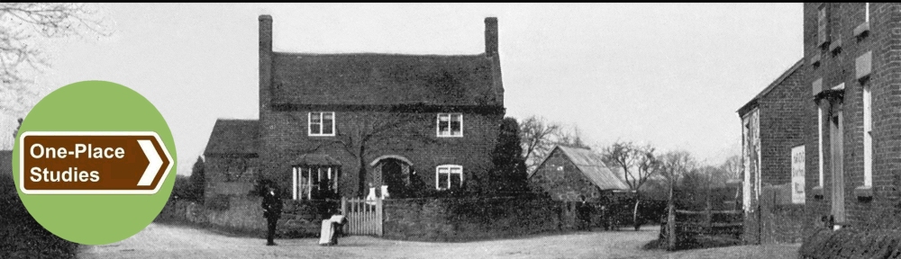
On this page I present extracts from The Geology of the Country around Wem which relate to Waters Upton and its immediate neighbourhood, also to the Tern valley, the Weald Moors, and other areas in the district, where relevant.
I have transcribed these extracts (accurately, I hope!) from a recently-purchased second-hand copy – the publication has not (yet?) been digitised by the British Geological Survey, and on Google Books it appears only in ‘snippet view.’ This material is reproduced under the Open Government Licence, under which I am obliged to note that this page contains British Geological Survey 🡕 materials © UKRI 1925.
In these extracts: […] indicates where I have omitted text; words in [square brackets] are my notes / explanations, or where I have made minor modifications to extracted text; numbers enclosed in {curly brackets} indicate numbers in the original text referring to footnotes; words in {curly brackets} and with a grey background are the footnotes to which the numbers refer.
Page i [🡑 Back to Top | 🡓 Down to Contents]
Memoirs of the Geological Survey
England & Wales
Explanation of Sheet 138
The Geology of the Country around Wem
By R. W. Pocock, B.Sc., & D. A. Wray, M.Sc.
With Contributions by
T. C. Cantrill, B.Sc.
London
Printed under the Authority of His Majesty’s Stationery Office 1925
Page iv [🡑 Back to Top]
Contents
[Limited here to chapter headings]
Chapter I.—Introduction [Page 1]
Chapter II.—Pre-Triassic Rocks [Page 6 (omitted)]
Chapter III.—Triassic Rocks [Page 22]
Chapter IV.—Triassic Rocks [Keuper; Page 35 (omitted)]
Chapter V.—Triassic Rocks [Raetic Beds; Page 49 (omitted)]
Chapter VI.—Jurassic Rocks [Page 51 (omitted)]
Chapter VII.—Folds, Faults, and Igneous Intrusions [Page 54]
Chapter VIII.—Glacial Deposits [Page 65]
Chapter IX.—Post-Glacial Deposits [Page 78]
Chapter X.—Glacial Lakes and River Development [Page 85]
Chapter XI.—Economics [Page 89]
Appendix I.—List of Principal Works of the Geology of the District [Page 103 (omitted)]
Appendix II.—List of Geological Survey Photographs in Sheet 138 [Page 106 (omitted)]
Index [Page 109 (omitted)]
Page 1 [Back to 🡑 Top / 🡑 Contents]
Chapter I: Introduction
Geographical Range
The district described in this memoir is that represented on Sheet 138 of the New Series One-inch map. It comprises an area of 216 square miles, mainly in the county of Shropshire, […]
Physiography
In general the district is one of low relief, averaging 300 ft. above Ordnance Datum, […]
Page 2
The River Tern, rising in Staffordshire, enters the district at Market Drayton, where it cuts a deep gorge in the Triassic rocks. At Ternhill it is joined by Bailey Brook, which drains a large area east and north of Prees. Thence it flows almost due south in a broad valley, very liable to floods, to Waters Upton and Crudgington, receiving on its left the Meese and the Strine.
The drainage of the whole area is sluggish, and this is especially noticeable in the north-west, where broad alluvial flats and extensive peat-mosses are developed. […] Similar sluggish conditions of drainage in the south-east corner of the district have given rise to the peat-flats of the Weald Moors.
Pages 2-3
Geological Sequence
The formations represented on the map and section are summarised in the following table:—
Superficial Formations
[Note: Only the formations marked with an asterisk occur within the historic parish boundaries of Waters Upton, with peat found only in the formerly detached part of the parish in the Weald Moors.]
Recent and Post-Glacial:—
Peat. [*]
Alluvium. [*]
River Terraces. [*]
Older River Gravel. [*]
Glacial Drift:—
Sand and Gravel, and associated Boulder-Clay and unbedded gravelly clay. [*]
Solid Formations
Jurassic:—
Lias:—
Middle Lias: marlstones, shales, and clays.
Lower Lias: grey shales and limestones
Triassic:—
Rhaetic: black and grey shales and limestones.
Keuper:—
Keuper Marl: red and grey marl, with thin sandstone (skerries).
Waterstones: red sandstone with marls.
Ruyton and Grinshill Sandstones: yellow and red freestone, passing down into the Bunter.
Bunter:—
Upper Mottled Sandstone: soft red sandstone.
Pebble Beds: pebbly red sandstone and conglomerate. [*]
Lower Mottled Sandstone: soft red sandstone. [*]
Unconformity
Carboniferous:—
Coal Measures:—
Upper:—
Enville Beds: red marls and sandstones, with calcareous conglomerates. Possibly Permian.
Keele Beds: red marls and sandstones, with a Spirorbis sandstone.
Unconformity
Pre-Cambrian:—
Longmyndian Series: greyish-green and purple shales, sandstones, and conglomerates.
Intrusive igneous rock:—
In Trias: dolerite dyke. […]
Page 3
Structurally, the Triassic rocks form an elongated synclinal basin, with its axis running south-west and north-east through the outlier of Lias at Prees. At intervals, round the outer rim of this basin, the Bunter sandstones and Pebble Beds come to the surface; but as they are for the most part covered with drift, the exact form of their outcrop in many parts of the district cannot be determined. […]
Page 5
The […] mapping of the superficial deposits […] has […] revealed the fact that character of the soil and the consequent agricultural conditions of a large part of the district have been determined less by the nature of the solid rocks than by the wide-spread deposits left by the glaciers and ice-sheets of the Great Ice Age.
Page 14 [Back to 🡑 Top / 🡑 Contents]
Chapter III: Triassic Rocks.
General Description, and Bunter
[…]
Page 16
The principal areas where the Triassic rocks are exposed are: in the south-west, […]; in the central part […]; on the east, from Waters Upton through Child’s Ercall to Little Drayton.
The more massive beds of the Keuper and Bunter divisions generally produce prominent features, the Bunter Pebble Beds forming the escarpments and ridges of Besford Wood, Booley, and Stanton-upon-Hine Heath, the rising ground of Hodnet, Grange Wood, and Salisbury Hill near Little Drayton, and the prominent scarp of Shray Hill near Waters Upton; […]
Bunter
This formation was divided by Hull into three stages: the Lower Mottled Sandstone, the Pebble Beds, and the Upper Mottled Sandstone. In this district no complete section of the Bunter is available, nor are there any records of wells and boreholes of sufficient depth from which the thickness of the formation can be deduced. From data collected in adjacent areas the total dimension of the formation may well be put at over 1,000 ft., the maximum figures for the various subdivisions being approximately as follows: Lower Mottled Sandstone, 650 ft.; Pebble Beds, 300 ft.; Upper Mottled Sandstone, 650 ft.
The relationship of the Bunter to the beds below is one of unconformity. North of Walton near High Ercall, and again west and north of Ollerton and at Colehurst Wood, the Lower Mottled Sandstone rests, not on the Enville Beds, but upon the Keele Beds; but at Hungryhatton the Lower Mottled stage is overlapped in a southward direction by the Pebble Beds, which in their turn rest on the Keele Beds.
Pages 16-17
The Lower Mottled Sandstone consists of soft, frequently incoherent, bright-red sandstone, occasionally mottled and blotched with yellow. With the sole exception of the section at Child’s Ercall (p. 20), no visible part of the formation is known to contain pebbles. False bedding on a large scale is notably prevalent.
Page 17
The Pebble Beds are more firmly compacted brown, red, and yellow sandstones, invariably containing scattered, small, and well-rounded pebbles, principally of quartzites. Few important beds of conglomerate or of closely massed pebbles, comparable with those of South Staffordshire, have been seen. At the base of the subdivision the pebbles tend to be angular and more abundant, and to consist in places of a greater extent of igneous rocks, some of which resemble the rhyolite of the Uriconian masses exposed near Wellington. […]
Details
Lower Mottled Sandstone
[…]
Page 18
On the eastern side of the boundary fault of the Keele and Enville Beds of Walton the Lower Mottled Sandstone reappears at High Ercall and extends thence to the Tern valley; but the outcrop, though comparatively free from drift, affords few sections. […]
Page 19
[…] the presence of red sand-rock fragments in the soil of the hedge-banks, together with the loamy and sandy character of the soil itself, shows that the Bunter sandstone comes to the surface south of Osbaston and Moortown.
At the cottages called Doody’s or Dody’s Pits, beside the Ercall and Crudgington road near the ninth milestone from Shrewsbury, some old pits show sandy soil and traces of red clay, and from one of them clay for brick-making is said to have been obtained. If this material was not a pocket of boulder-clay, it must be assigned to a lenticle of marl in the Bunter. At Moortown a shallow digging west of the farm buildings shows red sand, and a pond north of them has been excavated in laminated soft bright-red sand-rock. […]
[…] At Rowton the rock is exposed in the sides of the street, 250 yds. west of the church. Farther east, at waterside, it is to be seen in the Hodnet road. East of Cold Hatton a road, on approaching the railway, cuts through some 10 ft. of brownish-red sand-rock, coarse grained and markedly current-bedded, in which the layers dip north of west at 40°. […]
Pages 19-20
East of the Tern the Lower Mottled Sandstone emerges from the boulder-clay at Crudgington Leasowes, where it is capped with a small outlier of Pebble Beds ([🡓] p. 26). Here bright red soft sand-rock devoid of pebbles is visible at the foot of the eastern wall of the front garden. Similar rock in the form of fragments in the red sandy soil of the fields to the east, and an old pit, 520 yds. south-east of the house, in bright-red sand, prove the extension of this tract towards the Strine. […]
Page 20
At Waters Upton, Mr. Bromehead finds that the junction of the Lower Mottled Sandstone with the Pebble Beds is visible in the lane between the church and the Swan Inn. The exposure shows 8 ft. of dark sandstone (Pebble Beds) resting on 2 ft. of soft bright-red sandstone (Lower Mottled), the dip being eastward. At the south-west end of Shray Hill [🡓 see also page 27] a fine section of the same junction shows about 30 ft. of very pebbly false-bedded sandstone resting on 4 ft. or more of soft Lower Mottled sandstone with an uneven and eroded surface. The lower subdivision is seen again by the roadside at the southern extremity of the hill.
In the valley of the River Meese, a third of a mile south-east of Burleigh, the Lower Mottled Sandstone can be seen at the foot of a fine cliff of Pebble Beds.
A good section in the bank of the River Meese, a quarter of a mile south-west of Great Bolas church, was illustrated by Hull. {1} It shows very false-bedded pebbly sandstone, with a conglomerate base, resting on an eroded surface of the Lower Mottled Sandstone, which is soft, red, and laminated. […]
{1: Triassic and Permian Rocks of the Midland Counties of England (Mem. Geol. Surv.), 1869, p.36 and fig.13. [Digitised copy on the Internet Archive website 🡕]}
Page 22
Pebble Beds
[…]
Page 25
South-east of Moortown an outlier of Pebble Beds […] has been discovered. In it an old quarry, 480 yds. north-west of Crudgington Bridge (over the Tern) gives a good section in false-bedded flaggy sandstone, fairly hard, dark red and coarse grained, with scattered pebbles, up to 1½ in. in length, of quartzite and quartz. The dip appears to be north-eastward at 5°. The margin of the outlier makes but little feature, and its position is somewhat indefinite. […]
[On] Cold Hatton Heath, the high ground east of the Seven Stars appears to be capped with a small outlier of Pebble Beds; for Mr. Bromehead noticed signs of old pits and found the soil to be very pebbly.
Page 26
East of the Tern another, though small, outlier […] caps a knoll at Crudgington Leasowes. The exposure of Lower Mottled Sandstone already mentioned ([🡑] p. 19) is followed 30 yds. to the west (and 30 yds. south-west of the house), under the wall of the sunk fence before the front garden, by a section 14 ft. long and 2 ft. high in the Pebble Beds. The rock is a false-bedded red and yellow flaggy sandstone, with a few pebbles in the lower part, passing down into very pebbly sandstone or conglomerate. The dip is apparently westward, at about 5°. In the conglomerate the pebbles, which range up to 2 in. in length, consist of quartz, quartzite, and purple igneous rocks resembling the Uriconian rhyolite and tuffs and tuffs of the Wrekin. Though the junction with the Lower Mottled Sandstone is not laid open, it cannot be more than 3 or 4 ft. below.
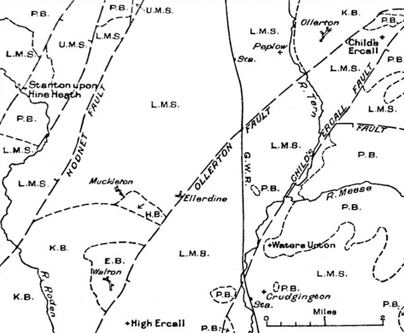
Fig. 1.—Sketch-map showing the neighbourhood of Muckleton and Ellerdine.
U.M.S. Upper Mottled Sandstone
P.B. Pebble Beds
L.M.S. Lower Mottled Sandstone
E.B. Enville Beds
K.B. Keele Beds
H.B. Halesowen Beds
Page 27
At Waters Upton Mr. Bromehead finds that, 150 yds. south-west of the church, a large old quarry shows 35 to 40 ft. of coarse hard brown sandstone of the Pebble Beds, dipping apparently to the north-north east at about 10°. In the upper part of the section the pebbles are scarce, and are small and somewhat angular; but in the bottom 20 ft. they are abundant, larger, and well rounded. At the lowest part of the section a 3-ft. bed contains many well-rounded pebbles, 2 to 4 in. in length, mostly of quartz and quartzite, red and grey in colour, with decomposed fine-grained igneous rocks, brown, yellow, and white in colour. The quartz grains of which the sandstone is chiefly composed are fairly coarse, angular and subangular in shape, and lack the thorough rounding of those in the Lower and Upper Mottled subdivision. Several bands and lenticles, up to 1 ft. thick, of white sandstone free from pebbles are present. The whole section shows current-bedding in wedge-like form. The rock was quarried in 1864 (this date is incised on the south-east face of the quarry) for the rebuilding of the church, and also for the construction of bridges on the Wellington and Market Drayton railway about 1866 [🡓 see also page 92]. The top of the Lower Mottled Sandstone lies about 6 ft. below the floor of the quarry, as soft red flags have been reached at that depth.
On the other side of the road a pit shows 10 ft. of pebbly sandstone with prominent white seams. […]
At Shray Hill, a mile and a half east of Waters Upton, a good section on the south-west side of the hill shows 30 ft. of very pebbly sandstone, much current-bedded, resting on an eroded surface of the Lower Mottled Sandstone ([🡑] p. 20). For a few feet at the bottom the Pebble Beds are coarsely conglomeritic, and occupy hollows in the underlying soft sandstone. On the east side of the hill an old quarry shows about 40 ft. of pebbly sandstone, dipping to the north-east.
The River Meese, a tributary to the Tern, has cut a narrow gorge-like valley in the Pebble Beds, in which good sections can be seen at various points […].
On the north bank of the river, half a mile south-east of Great Bolas church, pebbly sandstone is seen to a depth of 12 ft., and similar beds are exposed in the small coppice adjoining this section on the west. Pebbly sandstone is well exposed at Bolas Mill and also in the road to the south-west.
Pages 27-28
Half a mile south-west of Great Bolas church the northern bank of the Meese valley affords a fine section, 40 ft. high, of pebbly coarse sandstone, dipping apparently at 3 to 8 to the east. On the southern bank also there is a good section in the same beds.
Page 28
In the Tern valley, two furlongs south-west of Great Bolas church, the pebbly sandstones are well exposed in the steep left side of the valley. The section was illustrated by Hull {1}. It shows about 30 ft. of highly false-bedded pebbly sandstone, the lowest few feet of which are very conglomeritic and rest on hollows or pockets in the uneven surface of the Lower Mottled Sandstone, of which a thickness of about 2 ft., of the usual soft red laminated type, can be seen at the foot of the bank.
In the village of Great Bolas, pebbly sandstone is to be seen at the surface at many points, and also at Burleigh Farm, father east. The cellars at Burleigh are cut entirely in the rock, while 100 yds. north of the house the well, 15 ft. deep, proved rock to the surface. A shallow pit 400 yds. east of the house shows fissile coarse sandstone in place, and at Bolas Common Farm similar sandstone forms the bank of a pond. Some 400 yds. east-south-east of the same farm, pebbly sandstone has been quarried to a depth of 20 ft.
Close to the chapel, half a mile north at Bolas House, pebbly sand-rock is found, apparently in place. An east-and-west fault, throwing down to the south, passes just north of this point.
{1: ‘Triassic and Permian Rocks of the Midland Counties of England’ (Mem. Geol. Surv.), 1869, Fig.13 on p.36. [Digitised copy on the Internet Archive website 🡕]}
Page 54 [Back to 🡑 Top / 🡑 Contents]
Chapter VII: Folds, Faults, and Igneous Intrusions
[…]
Page 60
In the Tern valley south-west of Crudgington a fault […] can readily be proved at Tern Farm (just within Sheet 152), where a strip of Pebble Beds on the east is thrown down against Lower Mottled Sandstone on the west. Farther north its throw, which is small and uncertain, appears to change to a westward one; for the outlier of Pebble Beds south-east of Moortown, though at much the same level as that at Crudgington Leasowes, has a north-eastward dip. North of Waters Upton its throw, though still small, seems to revert to an eastward one. […]
Page 65 [Back to 🡑 Top / 🡑 Contents]
Chapter VIII: Glacial Deposits
General Description
The history of the Glacial deposits of this area is closely bound up with that of the drifts of the whole of the Cheshire and North Shropshire plain. There appears to have been two main streams of ice: one from the north and north-west, bringing debris from the north of Scotland, the Lake District, the Isle of Man, and the bed of the Irish Sea; and the other from the west, bringing large quantities of detritus from Arenig and other high ground in North Wales.
The Irish Sea ice-stream seems to have been the predominating influence, especially in the earlier stages of the glaciation, and at its maximum it spread its load of Scottish and Lake District granites and other rocks at least as far south as Wolverhampton.
The Welsh ice-stream appears to have made its influence felt at a period when the northern ice had already, to some extent, established itself in the area. That the main line of confluence of the two ice-streams extended southward through Wrexham and Ellesmere towards Shrewsbury is shown by the change in type of the bulk of the drift material that can be observed in crossing that line, Welsh detritus prevailing on the west and northern on the east. […]
Page 66
No clear and definite order of succession can be traced in the Glacial deposits; for they vary in their nature from place to place, and include unstratified stony drift and boulder-clay, with which are intimately associated irregular beds of well-stratified sand, gravel, and loam.
The unbedded stony drift and boulder-clay generally give rise to featureless slopes, whereas the bedded sands and gravels usually form billowy and hummocky ground diversified by numerous mounds and hollows […]
In the west the boulder-clays and gravels consist of materials of local origin, with a large admixture of Welsh boulders and pebbles […]. In the northern and eastern parts of the present area the materials of northern origin correspondingly increase in proportion, and those of Welsh origin are rare. […]
Wherever it has not been removed by post-Glacial denudation, this great sheet of drift levels up all the minor irregularities of the old land-surface, and attains in places a thickness of nearly 200 ft.
Conspicuous boulders, mostly of igneous rocks, are plentifully scattered over the whole district, though few seem to have been recorded. In the ground lying between Hadnall and Waters Upton, surveyed by Mr. Bromehead, the specimens noted range up to 6½ ft. in length, the average being 3½ ft.; about 7 per cent. are of granite (Northern) and 93 per cent. felsite and similar rocks (Welsh). […]
Pages 66-67
In [the] south-eastern part of the district, between Preston Gubbals and Waters Upton, part of which was surveyed by Mr. Bromehead, examples of many of the more conspicuous boulders have been collected. […] The general appearance of the whole suite points to the south of Scotland, the Lake District, and North Wales as the sources of the boulders. […]
Page 68
Details
[…]
Page 76
Shawbury.—[…]
Page 77
[…] The long and narrow belt of boulder-clay that follows a somewhat winding course for 2¼ miles from Ellerdine Heath to the Tern valley at Sitch Lane, opposite Waters Upton, may, Mr. Bromehead thinks, occupy a pre-Glacial valley in the Lower Mottled Sandstone. […]
Crudgington.—East of the Tern valley at Crudgington the usual loamy and sandy red boulder-clay comes on in force. It is to be seen in a deep ditch 400 yds. north-west of Crudgington Leasowes, and also in an old roadside pit and pond, 100 yds. south-west of the farmhouse, where it contains the usual Welsh pebbles, Keuper Marl skerry, and igneous rocks. It forms the low clay pasture-land south-east of Sleap and also that north of the Strine and the peat-moors. At the Spring its junction with the Bunter throws out water. […]
Weald Moors.—South of the peat-moors the usual boulder-clay occupies the south-eastern corner of the district. A large old pit, crossed by a footpath, in an arable field nearly 5 furlongs south of Rodway Bridge (over the Strine), showing pebbly drift soil, is said to have been made for materials during the construction of the road across Crudgington Moor in 1816-21. […]
Waters Upton.—East of Waters Upton, thin boulder-clay occupies the surface over considerable areas. […]
Page 78 [Back to 🡑 Top / 🡑 Contents]
Chapter IX: Post-Glacial Deposits
River Gravels.—[…]
In the Tern valley numerous terraces of sand and gravel have been observed at various heights above the alluvium. On the west side of the valley a terrace east of Moortown rises above the alluvium with a step of about 6 ft. In it a small pit 240 yds. north of Rowton Gorse showed (in 1915) 4 ft. of sand and gravel containing pebbles of Welsh grits, with quartz, quartzites, Keuper skerry, and igneous rocks. The constituents thus resemble those of the local Glacial drifts from which they were derived (except that a somewhat larger proportion of the flint-pebbles is noticeable in some of the terrace-gravels). Below Crudgington Bridge a similar terrace on the same side of the valley rises to about the same height above the alluvium.
Pages 78-79
On the east side of the valley a higher and older terrace runs northward from below Sleap and through Crudgington to Waters Upton. Its crest, which coincides closely with the line of the main road, rises about 30 ft. above the alluvium. At Crudgington a large old pit on the east side of the road between the Wesleyan chapel and the school, and another, 100 yds. north of St. Mary’s Church, show signs of gravel and light-red sand. A large sand-pit 250 yds. south-west of the church (and east of the Wellington road) may be the one that afforded the evidence on which Charlotte Eyton (1} based her description of these gravels in 1867 and 1869. Speaking, in the later publication, of the ‘low-level drifts of the River Tern,’ she says (p.70) ”A bed of this gravel was opened at Crudgington, in 1866, by the Wellington and Market Drayton Railway Company. It contains all the materials of the older drift; viz. red sandstone, chiefly ferrous limestone, granite, both pink and grey, and fragments of igneous rocks. To these are added a large number of flints, much chipped and rolled, and occasionally rolled pieces of lignite {2}. […]
Page 79
The bed lies about 100 yards from the bank of the River Tern. It is now much disturbed, having been used as material for the railroad.” […] By 1867 the working had been abandoned. The author mentions no particular pit, and […] it is not certain that the pit described by her was the one situated 250 yds. south-west of the church and named ‘Sand Pit’ on the six-inch map {3}. […]
(1: ‘On an Old Lake-basin in Shropshire,’ Geol. Mag., 1867, p. 1 [Extract on publisher’s website 🡕]; also ‘Notes on the Geology of North Shropshire,’ 8vo, London, 1869, pp. 69-70 [Digitised copy on Hathi Trust website 🡕].}
{2: Probably coal.–T.C.C.}
{3: Shropshire 29 S.E., edition of 1902.}
Pages 79-80
At Waters Upton, further north, Mr. Bromehead noted a low terrace, rising only a few feet above the alluvium. A higher terrace, about 30 ft. above the alluvium and probably to be correlated with the one of a similar height at Crudgington, is to be seen north of the church, on the left bank, and above Waterside on the right bank. Here, in a gravel pit on the west side of the Hodnet road, 100 yds. north of the Methodist chapel, a section showed, in 1915, about 4 ft. of incoherent pink sand, noticeably current-bedded, with thin seams of pebbles and streaks of coal-dust. The pebbles are mostly of Welsh slaty rocks, quartzites from the Bunter Pebble Beds, felsite, granite and other igneous rocks, with skerry sandstone from the Keuper Marl. Around Little Bolas other patches of this higher terrace can scarcely be separated from the Glacial gravel.
Alluvium.—[…]
The alluvium of the Perry, Roden, Tern, and other smaller streams is usually a yellow and brown stony loam, made up largely of material derived from the drift. The sluggish condition of the drainage over large areas has produced broad alluvial flats, generally peaty. The peat often attains considerable thickness.
Pages 80-81
In the south-east part of the district the low-lying tracts of peat known collectively as the Weald Moors (including Sleap, Crudgington, Rodway, Dayhouse, and Cherrington Moors, as well as the Weald Moors proper) are bordered locally by a margin of alluvium, in places peaty, elsewhere a brown stoneless clay. […] This alluvium presents no marked feature along its junction, either with the surrounding boulder-clay or with the peat into which it merges. It generally forms wet rushy pasture, crossed by drains in which the clay can occasionally be seen.
Page 81
Peat.—[…]
Page 82
On the Weald Moors (mentioned above, p.80) the peat is exposed in the numerous drains that intersect the surface; but as it is nowhere dug for fuel or other purpose, no deep sections are accessible, and no means of ascertaining its thickness and relations to the underlying deposits are available. Moreover, as it extends eastward and southward into adjacent maps the full story of its origin cannot be attempted in the present volume.
Pages 82-83
The Weald Moors have formed a subject of comment by several writers. Over two centuries ago the Rev. George Plaxton, rector of Kinnersley from 1673 till about 1703, remarked {2} that the whole parish and village of Kinnersley were at that time surrounded by a large morass called the Weald-Moor or Wild Moor, i.e., the Woody Moor; that within the memory of the oldest inhabitants the moors were densely overgrown with alders, willows, sallows, and thorns; and ‘spray’ of wood such as the floods left upon the surface; that, on digging into it, roots and stumps of oaks 3 or 4 ft. under the surface are found; and that the soil, which is peaty and is cut up for fuel, rests upon clay, sand, and other sorts of earth. He noted the fact (still observable) that the level of the ground had formerly stood much higher, for he had seen “Oaks and other Trees, where the present Soyl is so much shrunk and setled from them, that they stand upon high Stilts, and are supported from the great Fibres of the Roots, so that Sheep may easily creep under them.” Some draining had been carried out, and the moors had become good pasture. […]
{2: Phil. Trans., vol. xxv (1706-7), no. 310, article 6 [Index page on Royal Society website}; Digitised copy of article on Royal Society website (PDF) 🡕]}
Page 83
To sum up, it seems probable that, after the retreat of the ice, a low-lying tract, largely covered with boulder clay, was left, the deeper parts of which long remained under water, the supply being maintained by the drainage from the surrounding land. The outflow escaped by the River Strine, which flows westward by along the northern margin of the basin and joins the Tern at Crudgington. There is now another outlet, Beanhill Brook, which escapes from the basin at the south-west corner at Sleapford (Sheet 152). In view of the well-attested post-Glacial depression of Southern Britain, the area with which we are dealing probably stood at least 60 ft. higher that it now does. In course of time the sediment brought down by streams from the surrounding ground caused the silting up of the shallow margins of the waters; and the slow depression of the country may have lowered the gradient of the streams, checked the drainage, and encouraged the growth of peat in the central parts of the basin. The resulting swamps extending gave rise to a dense wooded jungle, which still further impeded the outflow of the water and encouraged further accumulation of peat. […]
Page 84
Excellent opportunities (not likely to recur) for recording the thickness and character of the peat and the strata underlying must have arisen during the installation of the drainage-system by the Marquis of Stafford about 1820; but although James Loch {1} has recorded many interesting details about the changes then introduced, he has given us little information bearing on the present aspect of the enquiry.
{1: ‘An Account of the Improvements on the Estates of the Marquess of Stafford, in the Counties of Stafford and Salop, and on the Estate of Sutherland. With Remarks.’ 8vo, London, 1820. [Digitised copy on Hathi Trust website 🡕]}
Page 85 [Back to 🡑 Top / 🡑 Contents]
Chapter X: Glacial Lakes and River Development
The great masses of coarse gravel, sand, and boulder-clay that cover a large part of the district, especially in the west and north-west, appear to have been deposited during the northward retreat of the ice. The gravels so remarkably exhibited between Ellesmere, Bettisfield, and Whitchurch (Sheet 122) are believed to be part of a terminal moraine thrown down during a pause in the retreat. […]
The melting of large quantities of ice lying immediately to the north of the present area during the last phases of the Glacial period would result in the production of extensive sheets of water over some of the lower tracts. The pre-Glacial drainage of the area is very generally believed to have flowed northward towards the Dee estuary, where the pre-Glacial surface has been shown to lie at a considerable depth below sea-level.
In the last phases of the Glacial period, and also in post-Glacial times, all outlets to the north were choked, first by the retreating ice-sheet, and subsequently by the morainic masses left by it. It was at this period that an extensive lake, for the existence of which considerable evidence has been adduced in the neighbouring districts to the south-east, especially at Newport and Buildwas, was formed over much of the lower ground. The general surface-level of this post-Glacial lake appears to have been about 300 ft. above O.D. […]
Page 86
The lake appears to have maintained its level at 300 ft. above O.D. for a long period, and in it were laid down the more evenly-bedded, finer, well-washed and sorted sands, gravels, and laminated clays found below that level. […]
Page 87
On the north the lake appears to have been held up, not by ice, but by the terminal moraine mentioned above […], thus acquiring a length of life and permanence of level greatly in excess of that of an ice-dammed lake.
This theory, that the waters were held up by the morainic deposits on the north, is borne out by the history of certain streams that rise on the watershed between the Dee and the Mersey on the north and the Severn on the south.
The morainic ground rises above the 300 ft. contour over practically the whole tract of country forming the watershed. […]
The River Tern enters the area of Sheet 138 at Market Drayton and flows westward in a relatively narrow valley to Ternhill, where it breaks into a broad north-and-south valley that must originally have been occupied by a much larger stream. This larger stream, which we may call the ‘Old Tern,’ laid down, in its valley, first gravel terraces, and later alluvium. The gravel terraces can be followed at intervals from Crudgington and Waters Upton in the south by way of Wollerton to beyond Longslow in the north. […]
Page 88
The Old Tern and the other streams of the areas were developed after the 300-ft. lake had been drained to the south through the Ironbridge gorge (Sheets 152, 153). […]
After remaining at 300 ft. for a long period surface of the lake seems to have fallen rapidly to about the 200-ft. level. This is suggested by a study of the terraces of the Tern. The main terrace, found at Longslow in the north, rises to nearly 300 ft. above O.D., where it merges with the supposed sands of the lake. Followed southward, it falls to about 200 ft. at Crudgington.
Page 89 [Back to 🡑 Top / 🡑 Contents]
Chapter XI: Economics
Copper Ore.—[Not reported from Waters Upton or its vicinity.]
Page 91
Building Stone.—The principal building-stone of the district is the Ruyton and Grinshill Sandstone. […]
Page 92
The Grinshill freestone has been widely used for building. It has been employed in many of the principal buildings of Shrewsbury, especially the railway-station, St. Chad’s Church, the Municipal Buildings, the Lord Hill Column, parts of St. Mary’s Church, and the Royal Infirmary. Other buildings in the county, built of this stone, are Moreton Corbet Castle, the manor-house at Preston Brockhurst, Acton Reynald Hall, Hardwicke Grange, part of Sansaw, Clive church, etc. […]
In the south-eastern part of the district building-stone of good quality is lacking. […] Some has been quarried from the Bunter Pebble Beds south-east of Moortown and from east of Rodway Farm. The large quarry in the Pebble Beds at Waters Upton ([🡑] p. 27) was worked in 1864-6 for bridges on the Wellington and Market Drayton Railway and for the rebuilding of the church. […]
Bricks and Pipes.—Bricks, tiles, and agricultural drain-pipes have been made here and there for local supply, mostly at small brickyards, many of which are now disused or worked only occasionally. The source of the material is usually the boulder-clay. […]
Page 93
At Mt. H. G. Bourne’s brick and tile works, situated a third of a mile south-west of Shawbury church, red bricks and agricultural drain pipes have been made from the boulder-clay for over a century; and formerly pottery and tiles also were produced. […] A brick-pit in the boulder-clay south of Cherrington […] was idle in 1919.
A brick-yard, standing idle in 1915, at the western end of the hamlet of Walton (p. 12) produced common red bricks from a marl-band in the Enville Beds. Bricks are said to have been made from a marl-band (or perhaps a pocket of boulder-clay) in the Lower Mottled Sandstone at Dody’s Pits […] between High Ercall and Crudgington.
The following list gives particulars of sundry brickworks that have been at various times in operation in the district. It is based on observations made during the recent re-survey, supplemented by what can be gathered from the six-inch Ordnance maps published in 1902-3. It is probably not complete. […]
Page 94
20. Shawbury; 3 furlongs S.W. of the church. Shropshire 29 N.W. At work in 1915. Boulder-clay.
21. Walton. At the west end of the hamlet. Shropshire 29 N.W. Idle or disused in 1915. Enville Beds.
22. Dody’s or Doody’s Pits, Cotwall, High Ercall. Shropshire 29 S.E. Traditionally the site of a brickworks. Either boulder-clay, or a marl-band in the Lower Mottled Sandstone.
23. Cherrington. Two furlongs S. of the cross-roads. Shropshire 30 S.W. At work in 1902; disused by 1921. Boulder-clay.
Roadstone.—Little roadstone, and none suitable for modern requirements, is obtainable from any part of the present district. The conglomerates in the Enville Beds were quarried, probably for this purpose, at Walton (p. 12), and Glacial gravel has occasionally been used. […]
Sand and Gravel.—Fine-grained loamy red sand has been obtained from the Lower Mottled Sandstone at Astley and Wheatley, and also at High Ercall, Osbaston, and Moortown. […]
Page 95
Building-sand when required for local use has been obtained from the Glacial sands and gravels, and from the river-terraces, wherever these are present, e.g., at Great Wytheford, High Ercall, and Crudgington. Gravel for roads and for ballast has been got from the same deposits. The supply is unlimited.
Peat.—[…]
Though peat abounds on the Weald Moors […] it is no longer utilized.
Marl and Marling.—The practice of digging marl and clay for use as a top dressing and for stiffening the light sandy soils of the Bunter and Glacial deposits has long been abandoned in this district. That it was at one time general is testified by the prevalence of old pits (now usually ponds, and the main source of water-supply for the cattle), which are to be found in most of the fields on the clay-lands—the Keele and Enville Beds, the Keuper Marl, and the boulder-clay. The practice when applied to cold lands on the Marquis of Stafford’s estates in the south-east part of the district was condemned in 1820 by James Loch {3}, who states that the custom had lately been prohibited and the pits levelled down, particularly in 1817. […]
Lime and limestone.—[…] No rock sufficiently calcareous for lime-burning crops out within the district […]
{3: ‘An Account of the Improvements on the Estates of the Marquess of Stafford . . . With Remarks.’ 8vo, London, 1820, pp. 190, 191. [Digitised copy on Hathi Trust website 🡕]}
Page 96
Water Supply.—[…]
Pages 98-99
Few springs occur in the south-eastern part of the district. […] At Moortown, near Crudgington, much water oozes from the junction of the boulder-clay with the Lower Mottled Sandstone and has given rose to a peaty swamp called the Quabs. {1} The same junction south of Shray Hill, Cherrington, throws out water at the Spring, and again 350 yds. south-east of Rodway Farm, the flow in this case being strong and the water probably pure. […]
{1: Quab or quob; a marshy spot; a bog, quagmire; a quicksand—Joseph Wright, ‘The English Dialect Dictionary,’ 1903. [Digitised copy on the Internet Archive website 🡕]}
Page 99
About Hadnall, Shawbury, and Waters Upton, in the parts of the district surveyed by Mr. Bromehead, most of the farms and cottages have their own wells, which are sunk in the Bunter sandstone, many of them through a cover of boulder-clay or of sand and gravel drift. […] In Waters Upton several wells reach water at only 12 ft. […]
[Back to 🡑 Top / 🡑 Contents]
