This page provides an introduction to the geology of the area in which Waters Upton is located, in the form of extracts from British Geological Survey maps 🡓, and extracts relating to North Shropshire from the third edition of The Welsh Borderland British regional geology 🡓 by J R Earp and B A Hains, published in 1971.
Geological map extracts
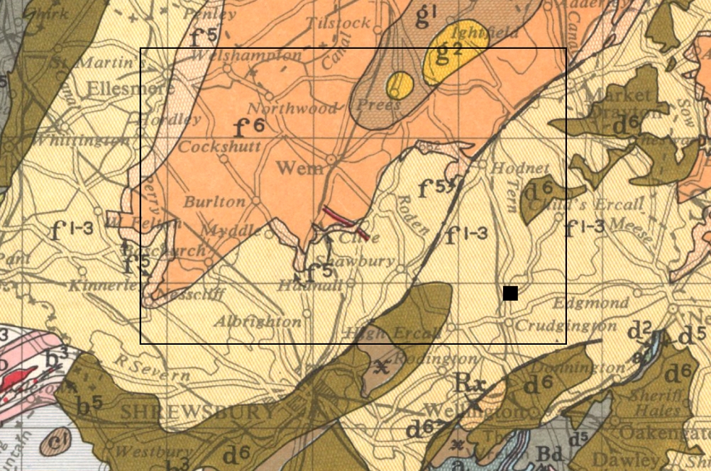
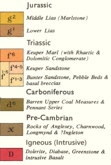
This is an extract from the Geological Map of Great Britain, Sheet 2, Second Edition, published 1957, showing North Shropshire with parts of neighbouring counties in England and Wales (view original here 🡕). This is a small-scale map (1:625,000), showing a simplified view of the bedrock (or ‘solid’ geology) which is either exposed at the surface, or which would be if it were not covered by more recent, superficial deposits or ‘drift’ (glacial, river, and lake deposits). I have added a small black square to show the location of Waters Upton, and a black rectangular outline to indicate, approximately, the area covered by the more detailed (1:63,360 scale) Geological Survey Sheet 138 (extracts from which can be found below). The key is a partial one, which I have constructed to show only the types of bedrock within the area covered by Sheet 138. It indicates that the rocks lying immediately below Waters Upton and its immediate neighbourhood, are the series including Bunter Sandstone, Pebble Beds and basal breccias, laid down during the Triassic period.
Map reproduced with the permission of the National Library of Scotland (maps.nls.uk 🡕) under a Creative Commons licence 🡕.
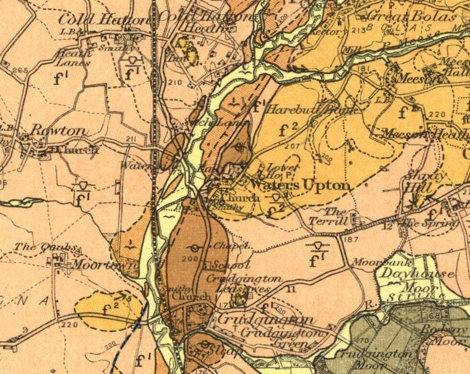
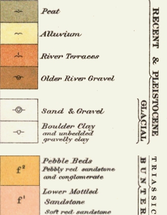
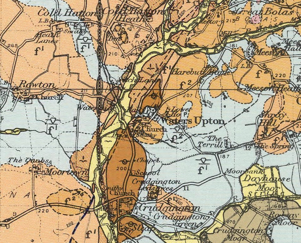
This is an extract from Geological Survey Sheet 138; the ‘Solid’ version (published 1924, view original here 🡕) which shows bedrock and recent deposits, with glacial deposits indicated by lines and symbols but not colouring. This shows that the higher ground within and in the immediate neighbourhood of Waters Upton, lies on rocks of the Pebble Beds, with Lower Mottled Sandstone below occupying the lower ground. It also shows that the bedrock is overlain by more recent deposits along the course of the rivers (especially the Tern, but also its tributaries the Meese and Strine) in the form of river gravels, river terraces, alluvium and, in those parts of the Weald Moors included in the map extract, peat.
Map reproduced under the Open Government Licence; contains British Geological Survey 🡕 materials © UKRI 1924.
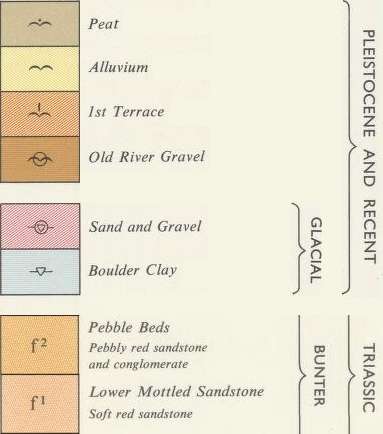
The ‘Solid and Drift’ version of Geological Survey Sheet 138 (published 1967, view original here 🡕) makes clear the extent to which glacial deposits cover the bedrock in the Waters Upton area. These deposits, chiefly in the form of boulder clay but also sand and gravel, were left when the ice sheets retreated at the end of the Great Ice Age.
Map reproduced under the Open Government Licence; contains British Geological Survey 🡕 materials © UKRI 1967.
Extracts from The Welsh Borderland British regional geology
The basic information on the geology of the wider North Shropshire area provided below is taken from The Welsh Borderland British regional geology by J R Earp and B A Hains, third edition, published 1971 (contains British Geological Survey 🡕 materials © UKRI 1971; view in full here 🡕). I will shortly be adding more detailed information, extracted from a memoir published in 1925 to accompany Geological Survey Sheet 138, on a separate page.
Chapter 1: Introduction
Physical features and drainage
The main physical features of the Welsh Borderland may best be described from north to south.
The district is bounded on the north by the great plain of north Shropshire, floored by Coal Measures and Triassic rocks which rest upon the northern slopes and spurs of the old Palaeozoic mass to the south and are largely obscured by a mantle of drift deposits, consisting of boulder-clay and glacial sands and gravels, brought into the district by ice both from the Irish Sea and from the Welsh Mountain area to the west. […]
Geological history
The mountainous terrain which resulted from the main Hercynian earth movements was denuded under continental conditions during Permian times by a climatic environment which favoured deep oxidation of much of the land surface. […] The deeply weathered terrain was then gradually buried during early Triassic times by mainly sandy sediment, some of which may have accumulated under arid or semi-arid conditions. The main depressions filled by the sandy Bunter sediments were later inundated by brackish water from an extensive land-locked sea, and, during later Keuper times, red muds with evaporite minerals accumulated in these areas. […]
The history of the rock formations of the region ends with the Trias, all later stratified deposits having been removed by denudation; and there only remain to be mentioned the deposits of the Glacial and post-Glacial periods.
Ice moving from south-west Scotland down the Irish Sea advanced over the North Shropshire plain probably during two periods within the last 100,000 years, and pressed against the northern side of the old Palaeozoic mass of south Shropshire, while Welsh ice descended from the hills down the Severn Valley and farther south into the valleys of the Teme and Wye. A discussion of these episodes is given in more detail later. On the retreat of the ice tumultuous deposits of sand, gravel and boulder-clay were left behind, masking the solid rocks over large areas. The rivers were, in many cases, now obliged to find new channels, and the present system of drainage is to a large extent a legacy of the Pleistocene glaciations. […]
Chapter 8: Triassic
Triassic rocks fringe the region to the north in Shropshire and to the east in Worcestershire. In Shropshire only the Bunter formation is represented within this region and the area which it underlies is largely concealed by superficial deposits. […]
Bunter
The Lower Mottled Sandstone of Shropshire is up to 600 ft (183 m) of medium to coarse grained non-pebbly reddish brown sandstone with greenish patches. It is usually highly cross bedded and the steep inclination of the laminae together with the rounded character of the grains suggest that it originated as a wind-borne deposit. […]
The Bunter Pebble Beds of Shropshire consist of some 150 ft (46 m) of sandstones of a rather coarser grain than the Lower Mottled Sandstones with pebbly layers and beds of soft conglomerate. The pebbles are mostly of quartz and quartzite […]
Chapter 9: Structure
Post-Triassic structures
Evidence of post-Triassic earth movements in the Welsh Borderland region is provided by the gently tilted lie of the Bunter Sandstone in the Shrewsbury area and the transection of the Bunter outcrop by a number of mainly N.E.–S.W. faults. […]
Chapter 10: Pleistocene and Recent deposits
Little is known of the history of the Welsh Borderland region during the greater part of the Pleistocene Period when southern and eastern England were subjected to complex erosional and depositional cycles dominated by the earlier Pleistocene glaciations. There is, however, abundant evidence that during the last 100 000 years or so the region was subjected to very severe glacial conditions. […]
The advance of the ice
During the main glaciation most of the region was invaded by streams of ice fed from the mountains of Wales to the west and north, while the Shropshire area was overwhelmed by the south-eastern lobe of a great sheet of ice fed from west Scotland and the Lake District which filled the Irish Sea basin. […]
The boulder-clay deposited by the Irish Sea ice is commonly reddish in colour and, in many places, sandy. That from the Welsh ice is generally brown; but where the ice passed over red rocks […] it is red. […]
Glacial retreat phenomena
The melting and retreat of the ice of the main glaciation from the Welsh Borderland region released enormous quantities of water into an area many of the former drainage routes of which were blocked by stagnant ice or choked with glacial debris. There were many areas where the drainage was so effectively dammed that great volumes of impounded static water, much of it sub-glacial, accumulated, while escaping surface and sub-glacial waters cut channels into everything which impeded their flow, and many of the channels transected former watersheds. Erosive and depositional activity reached a crescendo of vigour as channels were deepened and vast masses of till were swept away by the torrents; glacial sand and gravel were deposited within and around the melting ice and fluvio-glacial terraces of sand and gravel accumulated rapidly downstream in valleys emerging from a rigorous periglacial regime. […]
Post-Glacial
Evidence of the geological history following the final deglaciation of the Welsh Borderland region is furnished by deposits of peat in waterlogged hollows and on the more elevated tracts of moorland, and by floodplain flats and low-lying terraces of silt, sand and gravel along the floors of the river valleys. […]
